
If anchorages could talk, what stories would they tell? Tales perhaps of those who have come and gone—some putting down roots, others merely setting foot on shore for a few hours.
The past isn’t always apparent, for nature quickly reclaims signs of human presence. But there will be traces. Some are prehistoric, such as a shell midden bordering the anchorage. Others are more recent. There could be some gnarled fruit trees still standing in an overgrown orchard or an abandoned wood cabin slowly succumbing to the elements. For long-time boaters like us, there is often nostalgia when revisiting favourite anchorages and the happy memories they evoke of days spent with energetic dogs and question-filled children and old friends with whom we shared a few laughs.
There are many beautiful anchorages along our coast and the lucky ones are protected by park status. Marine parks are plentiful and this is especially true of the Gulf Islands, where a number of provincial marine parks became part of a national park reserve in 2003. Lying in the lee of Vancouver Island, the sheltered Gulf Islands enjoy a mild climate in which a variety of plants flourish, including arbutus and Garry oak. With a decent heater on board, boaters can cruise the Gulf Islands year-round. In our early days of boating, we spent many weekends crossing the Strait of Georgia to spend a night or two anchored in an idyllic cove, often having the place to ourselves in the off-season. Mind you, when winter weather systems roll in from the North Pacific, the Gulf Islands receive their share of wind, rain and, occasionally, snow.
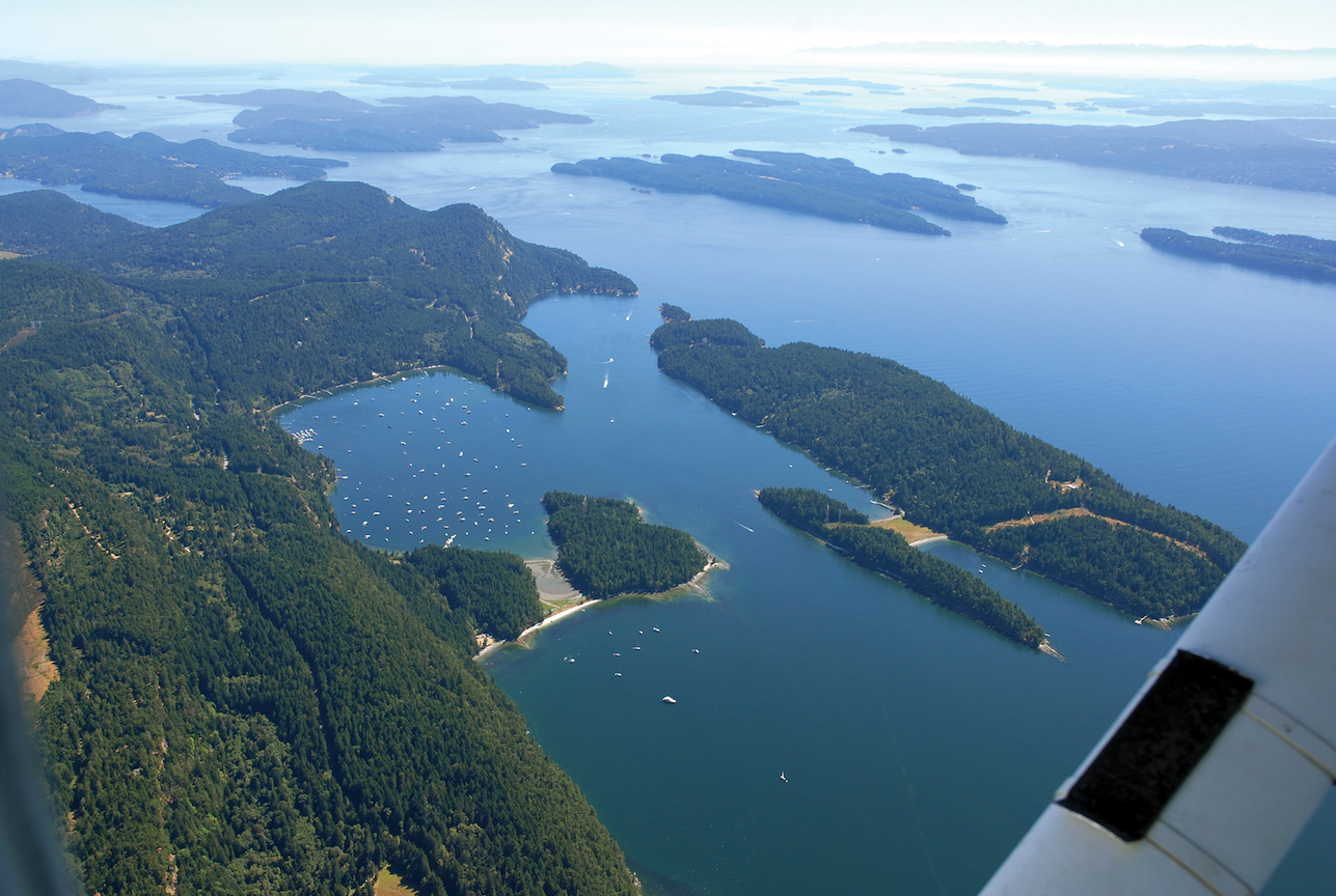 Aerial of Montague Harbour, Galiano Island.
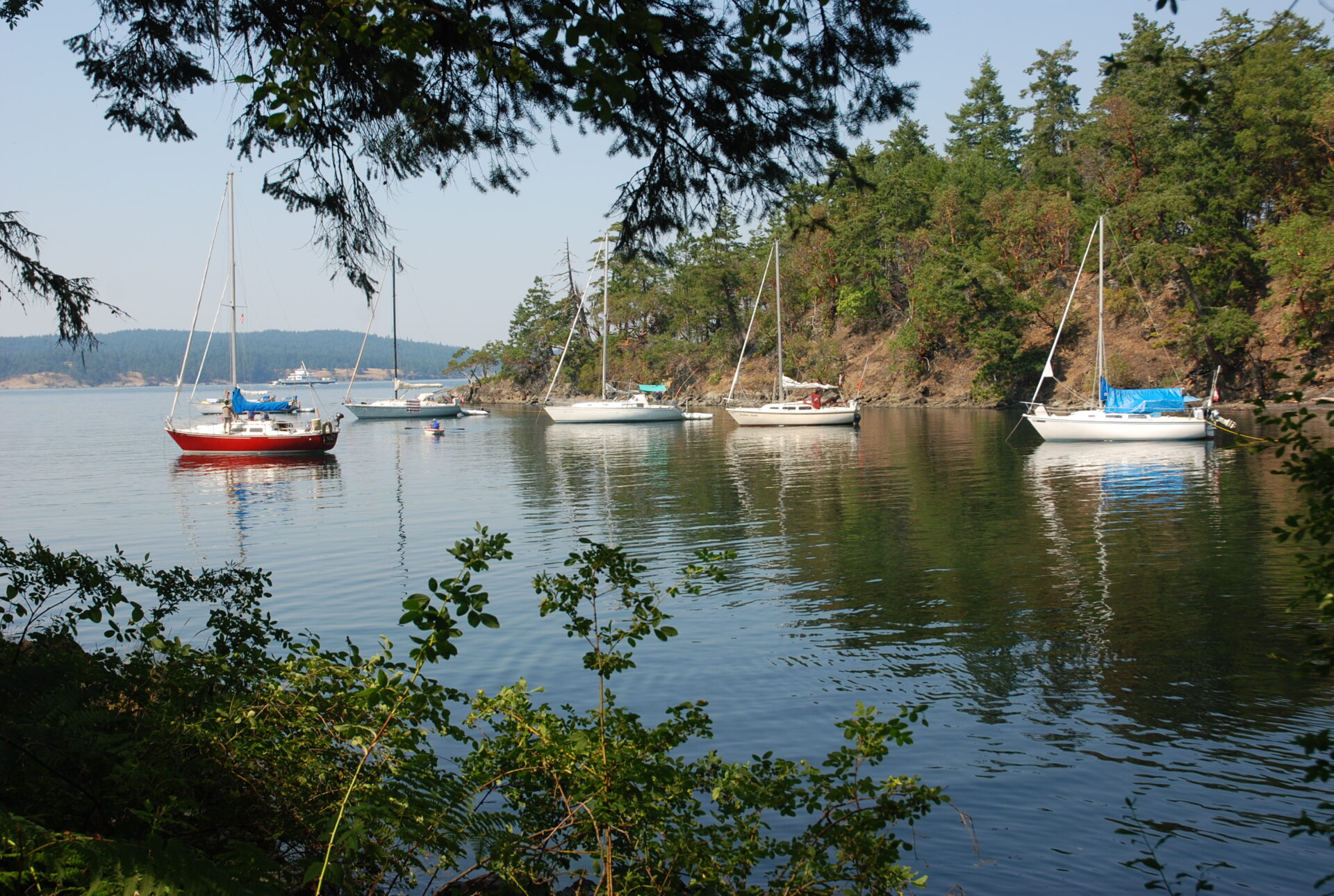
1. Montague Harbour
One year, over the Christmas holidays, we sat out a blizzard in Montague Harbour. Initially we were on a mooring buoy, but an intensifying southeasterly and blowing snow prompted us to move to the empty dock and spend the night securely tied up while snow steadily fell. Our diesel stove kept the saloon warm and by morning the wind had shifted to a northeasterly with gusts of 35 knots being reported at East Point on Saturna Island. When the winds finally subsided and the sun made a brief appearance, we ventured ashore in knee-deep snow. The marine park had been transformed into a winter wonderland and we happily trudged in our rubber boots through the deserted campground. On that winter’s day, we had the place to ourselves. The beaches enjoyed by swimmers and sunbathers in summer were now dusted with snow. Montague Harbour was British Columbia’s first marine park when established in 1959. Today, it’s a favourite destination with just about everybody. There’s always room to anchor in this large harbour, which can easily handle dozens of vessels. If the marine park anchorage is too busy for our liking, we anchor at the opposite end of the harbour, where the marina and store are located. From here we have hiked along winding island roads to Bluffs Park overlooking Active Pass, for an eagle eye view of its western entrance.
There are plenty of attractions at Montague Harbour—park trails, beaches, access to restaurants—but we tend to avoid this popular harbour at the height of summer and seek quieter anchorages in which to spend our weekends.
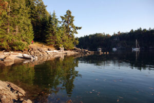 Selby Cove, Prevost Island
2. Prevost Island
This is what drew us to the pastoral peacefulness of Prevost Island. Much of the island is still privately owned by a farming family descended from Digby de Burgh, an Irish nobleman who bought the island in the 1920s for raising sheep, goats and cattle.
Selby Cove became one of our regular hideaways when we spotted a nook along its northeast side. There we would anchor in two fathoms, set a stern line and be sheltered from all winds and any wake from ferries in Captain Passage. Then, one spring, a house was built overlooking “our” nook. So, we looked for another one farther into the cove and found a new spot to anchor in a bight along the same shore. Gently rising from its beach is a grassy slope bordered by spruce trees. As we mulled the inevitable changes coming to the Gulf Islands, we wondered how much of Prevost Island’s waterfront would soon be dotted with houses and docks. We needn’t have worried.
In the spring of 1996, the Pacific Marine Heritage Legacy acquired 100 acres of land at the northwest end of Prevost Island, including the entire Pelee Point peninsula. Private property became public parkland and sheep trails were now footpaths, allowing boaters to explore beyond the grassy knolls and arbutus-clad cliffs bordering the anchorages. From our nook in Selby Cove we could hike to James Bay, where most of the surrounding shoreline was now park property (eventually becoming part of the Gulf Islands National Park Reserve). The trail leads past a small orchard and an open-field camping area overlooking the broad gravel beach at the head of James Bay. If the apples in the orchard are ripe, park visitors are welcome to pick a few.
We have often sought shelter in James Bay, especially in winter when southeasterlies blow. If strong gusts from the south do make their way into the bay, the heavily treed shoreline serves as a buffer while the anchorage’s deep water and good holding ground will keep a well-set anchor from dragging.
In summer, when the weather is settled and sunny, we enjoy visiting the islets lying off Prevost Island. Privately owned Owl Island consists of two islets joined by a shell beach at low water—a good spot to beach a dinghy and go for a quick swim. One time we didn’t notice the rising tide had lifted our dinghy and set it adrift and we stared in wild surmise as the current in Captain Passage began to carry it away. Finally, Bill, realizing an expensive asset was heading out to sea, threw down his Pacific Yachting cap and swam out to retrieve the dinghy.
 Hawkins Island.
3. Hawkins Island
On the other side of Prevost Island lies tiny Hawkins Island. This pristine islet is part of the national park reserve and access is restricted due to it being a habitat for several species of birds, including oystercatchers and migrating surf scoters. Back in the 1980s we would spend many a Saturday afternoon on this rocky islet when it was crown land and the only other visitors were the occasional river otter. After dropping anchor in the channel between Prevost Island and Hawkins Island, we would toss a picnic basket into the dinghy and row ashore to a pocket beach of crushed clamshells.
There we would set up a sun canopy using a tarp and lines from the boat and sticks of driftwood we found lying on the foreshore. The view from our picnic blanket was of sailboats lazily making their way up and down Trincomali Channel in the summer breeze. We would leave Hawkins Island in late afternoon when the tide was rising and our little beach disappearing. Other islands beckoned.
4. Portland Island
Another of our perennial favourites is Portland Island, designated a marine park in 1967 and named in honour of Princess Margaret, the younger sister of Queen Elizabeth. Now part of the Gulf Islands National Park Reserve, the island is one of the few marine parks where a boater can check out all of its anchorages on foot, for an extensive trail system encircles and crisscrosses the entire island.
The most popular cove, Princess Bay, is at the island’s south end, behind the Tortoise Islets. A fair-weather anchorage open to south winds, it is popular in summer during settled conditions. A good lunch stop lies on the west side of the island, in a bight south of Kanaka Bluff, where a lovely shell beach stretches along the shoreline. Portland Island’s other overnight anchorage, Royal Cove, lies at the north end of the island behind Chads Island (a privately owned islet). Our attention was first drawn to this cove when we noticed a lone sailboat anchored there, its bow pointed towards the ferry swells that roll in during the day. So, on our next visit to the island, we pulled into this cove for the night. It was a late-October weekend and no one else was there as we set the anchor and tied a line to shore.
Our solitude was short lived, for we soon heard a man’s voice calling from shore. He asked if we had any drinking water we could spare. Ten minutes later he returned with a small group of backpack-laden boy scouts. Bill rowed ashore to collect their hodgepodge of containers, which we filled from our water tank. ‘Be Prepared’ is the Scouts’ famous motto and the movement’s founder, a Victorian-era British army officer named Robert Baden-Powell, was once asked, “Prepared for what?” His response: “Why, for any old thing.”
Many things can go wrong when anchoring in a small cove and boaters should be mindful of the drying shelf on both sides of the Royal Cove anchorage. One summer, while sharing this anchorage with a dozen other boats, we were stern-tied along the cove’s western shore near the entrance when our keel caught on a ledge as the morning tide ebbed. The depth sounder showed enough water under the bow, but our stern was resting on the smooth, flat rock protruding, about 30 feet from shore. There we sat, lifted once or twice by ferry swells but with no damage, until the tide turned to flood and carried us off.
A dinghy dock on the cove’s west side provides easy access to the island’s trail system. There are several undeveloped campsites on the island, including one at nearby Arbutus Point, but there is no potable water. Wild sheep used to roam the island and a visit in springtime was a chance to see newborn lambs. In 1989, to prevent damage to the island’s grassland and wildflowers, the sheep were rounded up and removed. However, the apple orchard planted long ago by Hawaiian settlers is still thriving. During the fur trade, when Hawaii was a principal stopover port for merchant ships carrying sea otter pelts across the Pacific to Asia, the Hudson’s Bay Company employed numerous Hawaiian men (called Kanaka) as crew on their ships. When the fur trade dwindled, they began settling in the Gulf Islands and pursued their natural skills in fishing and farming.
Long before the arrival of Hawaiian settlers on Portland Island, there were the Coast Salish, whose former village is gone, but the beautiful midden beach remains, stretching along the island’s west shore, opposite Brackman Island. An ideal place to land a dinghy or kayak, these brilliant white beaches of crushed shell—formed over time from shucked clams and lying several metres deep—were helpful navigational aids for canoe-paddling crew returning to shore after dark.
 Royal Cove, Portland Island.
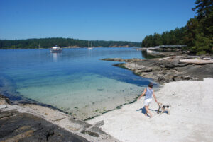 Russell Island.
5. Russel Island
Russell Island, lying across Satellite Channel at the mouth of Fulford Harbour, is also part of the national park and it too was settled by Hawaiians. William Haumea already owned property at Eleanor Point on Salt Spring Island when he purchased nearby Russell Island in 1886, clearing land to plant an orchard and strawberry field. Fifteen years later, Maria Mahoi inherited the small island and moved there with her second husband and brood of children. They added a large vegetable garden, kept chickens and dairy cows, and fished and collected clams. Their house still stands and descendants of Maria Mahoi are today volunteer park hosts, sharing their personal history with visitors.
Boats anchor in the lee of the island, where a white shell beach overlooks the anchorage and a dinghy dock provides access to shore, where a loop trail leads to the Mahoi homestead and around the western end of the island. The anchorage is sheltered from south winds and the holding ground is good.
6. Saturna Island
When summer slips into fall, we often head to Saturna Island. This large and sparsely populated island has always appealed to us, especially in the off-season. In fall, we would anchor in Lyall Harbour and row to the hamlet at the head, where a public tennis court beside the local school was always empty. Big maple leaves would lazily fall onto the court, adding to the mellow atmosphere as we played a casual game of tennis. Other times we would hike up the hillside, taking the road that winds through the village up to East Point Road, where a general store is situated at Narvaez Bay Road junction. One summer we walked for several miles along the quiet winding roads leading up to Mount Warburton Pike. The views from atop the summit were spectacular.
In our early days of boating, we once spent a Christmas Eve anchored in Winter Cove in the company of a dozen seals. It was a calm night, the only sound being the occasional splashing of a flipper near our boat. Since then, a dinghy dock has been installed in Winter Cove, next to the boat launch. From there, a trail loops through the woods and along the Strait of Georgia shoreline to Winter Point, where you can watch the tide rushing through Boat Passage. Wildflowers bloom there in spring.
 Kendrick Island.
7. Kendrick Island
As much as we enjoy exploring the Southern Gulf Islands, an anchorage we began to regularly visit lies at the north end of Valdes Island. We had passed it many times when transiting Gabriola Passage but never stopped to investigate. The anchorage lies between Kendrick Island and the east side of Valdes Island, at the entrance to Gabriola Passage. When crossing the Strait of Georgia from Sand Heads, we appreciated the fact there was no need to time our arrival to coincide with slack at a pass. There is a constant one-knot current flowing through the anchorage but it’s almost always in a northerly direction. The best place to anchor is north of the docks and buoys belonging to the West Vancouver Yacht Club, which owns Kendrick Island. South of here the water shoals quickly and the bottom is strewn with kelp.
Although strong south and north winds will gust through the anchorage, the holding in thick mud and sand is excellent, making it safe for most summer conditions. The islets lying southeast of Kendrick Island are part of Wakes Cove Marine Park and are perfect for swimming and sunning on the smooth sandstone. Water erosion has etched beautiful honeycomb patterns and wavelike shapes into the porous rock of these islets.
On the Valdes shore, we have often landed a dinghy and hiked the park trail, which overlooks the anchorage before turning inland toward Wakes Cove. We have also accessed the park trails by motoring over to Wakes Cove in the dinghy (when current isn’t running in Gabriola Passage) and tying up at the park’s dinghy dock. Our family photo album contains plenty of pictures of the Kendrick Island anchorage. The stories it could tell include the happy times we have spent there.