
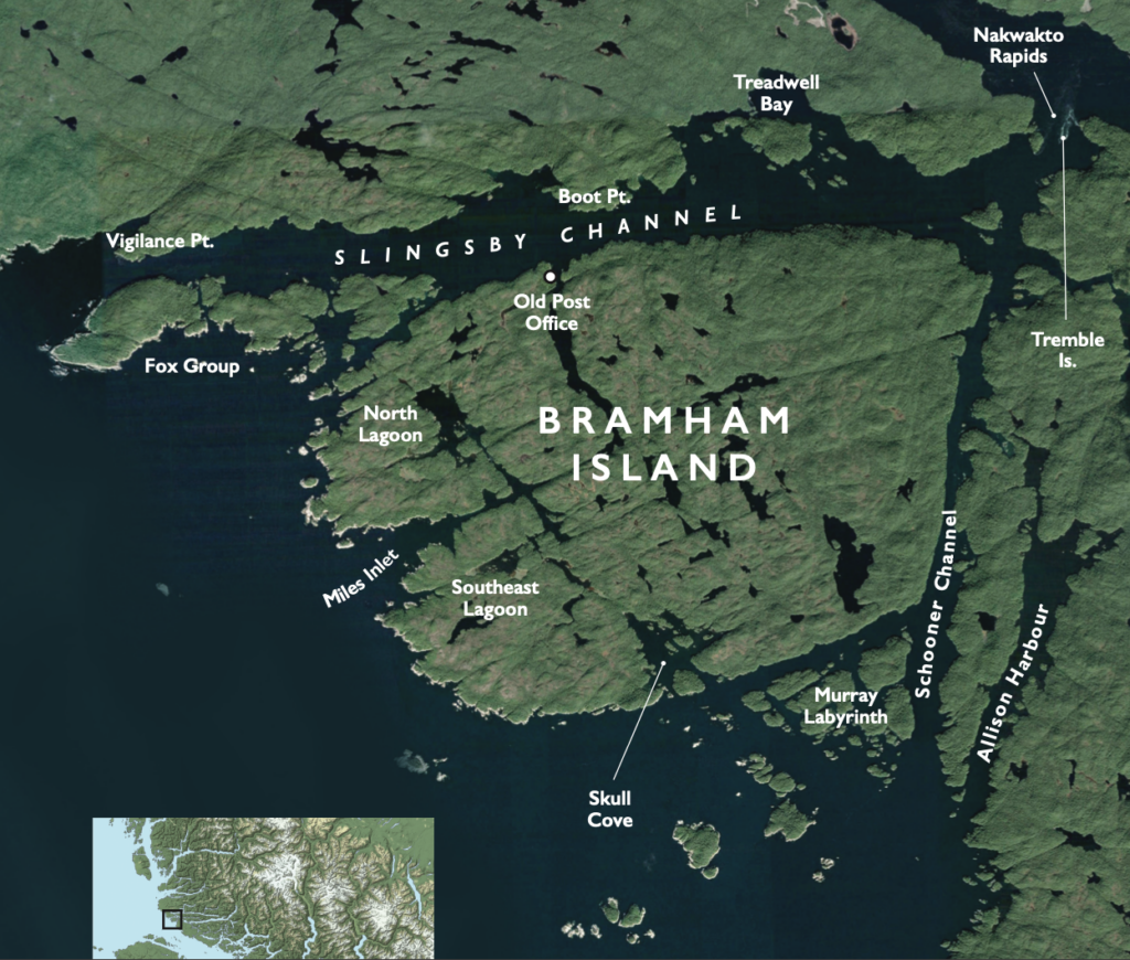
For anyone cruising the BC Coast beyond the Broughton Archipelago, there is much to explore around Bramham Island while waiting for conditions to settle at Cape Caution. There are excellent anchorages, a labyrinth, history, channels both wild and calm; but most importantly, there is a feeling of quiet solitude about the area that suggests you are free of the madding crowd (to quote Thomas Hardy) and have reached your place of Zen. Stay on that path, and enlightenment will surely follow.
Most cruisers will reach Bramham Island via the Southgate Group just to the southeast. The name suggests a tube station on the London underground, but has a more mundane origin. Captain Southgate was a merchant marine skipper who came to BC during the gold rush and was master of a number of commercial vessels for a decade, before retiring to England. He had the good fortune to be a friend of Captain Richards, master of the Hudson Bay’s Beaver, which surveyed much of Queen Charlotte Strait in detail, and named many of its minor locations (unaware that most, if not all, already had Kwakwaka’wakw names).
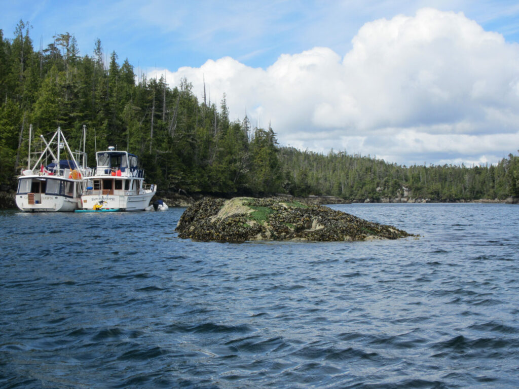 Murray Labyrinth provides an excellent refuge from prevailing summer northwesterlies, but beware the drying rock in the mid-basin.
The Southgates offer excellent anchorage to the east of Knight Island and are a snug bolt hole even in a howling northwester. The little archipelago has some 30 islands and islets and makes for superb exploring by dinghy or kayak, with a wide variety of marine life. The inner, calm shores are very different from the exposed western sides of Arm, Tinson and Knight islands where large California mussels, giant barnacles and palm kelp revel in the surf zone.
Another nice thing about the Southgates is you may enter from the south and exit from the north (or vise versa) with ease, and the transition from rolling swells in the open strait to the marvelously flat sea is a much-anticipated pleasure as you butt into the wind toward them.
Just north of the Southgate Group is Allison Harbour, sometime referred to as “false Schooner Channel” because in foggy conditions, which are common in the summer, the two entrances, side-by-side, may be confusing. Thanks to modern GPS they are now less so, but when transiting the bay between the Southgates and Allison Harbour, a skipper’s attention (especially in fog) is generally concentrated on avoiding the many reefs (well charted) that stand off the shores, rather than finding the correct entrance. Proceed with caution.
The back of Allison Harbour was at one time a thriving pioneer community of float homes, fishermen and loggers, many with their wives and families in tow. It offers a wide, safe anchorage in five to 15 metres (16 to 60 feet) over mud. At the very head of the bay are nooks and alleys to the north that should be explored by dinghy, kayak or paddleboard while around the island to the northeast, old steel boilers and winches are a reminder of a bygone age when the entire coast was alive with small, independent operators. Indeed, in 1937 when Betty Carey rowed alone from Washington state to Alaska (Bijaboji, re-issued by Harbour Publishing in 2006), there were very few nights that she camped out. Almost without fail, some unexpected host materialized to offer her supper and a warm bed for the night. Allison Harbour was one such place.
I have told the following story in Pacific Yachting before, but it bears repeating. One misty morning we motored up Schooner Channel, planning to transit Nakwakto Rapids at slack water, and ran into a pod of killer whales, also north bound. They weren’t residents, but transients, and the question arose as to what they, an open ocean species, were doing in so tight a passage. The answer came once we had successfully passed through the rapids at slack. As the tide turned and eddies began to swirl around Tremble Island (its official name is Turret Island), we saw hundreds of white-sided dolphins approaching the rapids in Seymour Inlet, bound for the open sea. Hidden behind an acoustic curtain of turbulence, the orca waited—the perfect ambush. I have often wondered how they knew the dolphins would exit on that tide, and how it all turned out.
 Exploring the south arm of Miles Inlet. At high tide, there are nooks and spillways that provide access to further lagoons and bays.
Across Schooner Channel from Allison Harbour lies the mysteriously named Murray Labyrinth. Who doesn’t love a maze? Especially if your vessel has to follow a tight course getting in and out? The secret route is not so hard to find. Avoid the north and east entrances which, at high tide, look deceptively simple as you gaze over wide water into the sanctuary inside. Both are foul. The only safe entrance is on the southwest side and involves a hard turn to port and then back starboard before gaining the inner sanctum. I would guess vessels as large as 50 feet could squeeze in there, although I’ve not seen anything large than a 47-foot Bayliner.
The channel is shallow, but certainly not close to on a high tide. Proceed slowly; a bow-thruster is always handy for sharp course changes. Just before the turn to port, some charts show a reef immediately ahead, which makes the manoeuvre appear more challenging than it actually is. A careful examination (in kayaks) at low tide turned up no such shallows, apart from the island ahead. But cave nauta (sailor beware) as they used to say in Rome.
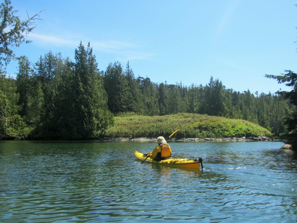
Once inside (the basin provides a wonderful refuge in a big blow) anchor in three to five metres (10 to 16 feet) over mud and sand. Pay special attention to the drying rock almost mid-basin which is hidden at high tide. However, there’s lots of room around the sides. Once settled, there are a multitude of islands, islets, channels and bays to explore by dinghy, kayak or paddleboard, and there’s good crabbing in the outer bay, and salmon fishing in the strait.
Murray Labyrinth is separated by a narrow east-west channel from Bramham Island to the north. Like everything else in the region, the shores are white granite, glacier scoured and sea washed to a pleasing sculpted roundness that make artists reach for their brushes the moment the anchor is set. On a sunny day, the combination of blue sea, white rocks, green forest and cerulean sky makes even the most blinkered of boaters want to write poetry.
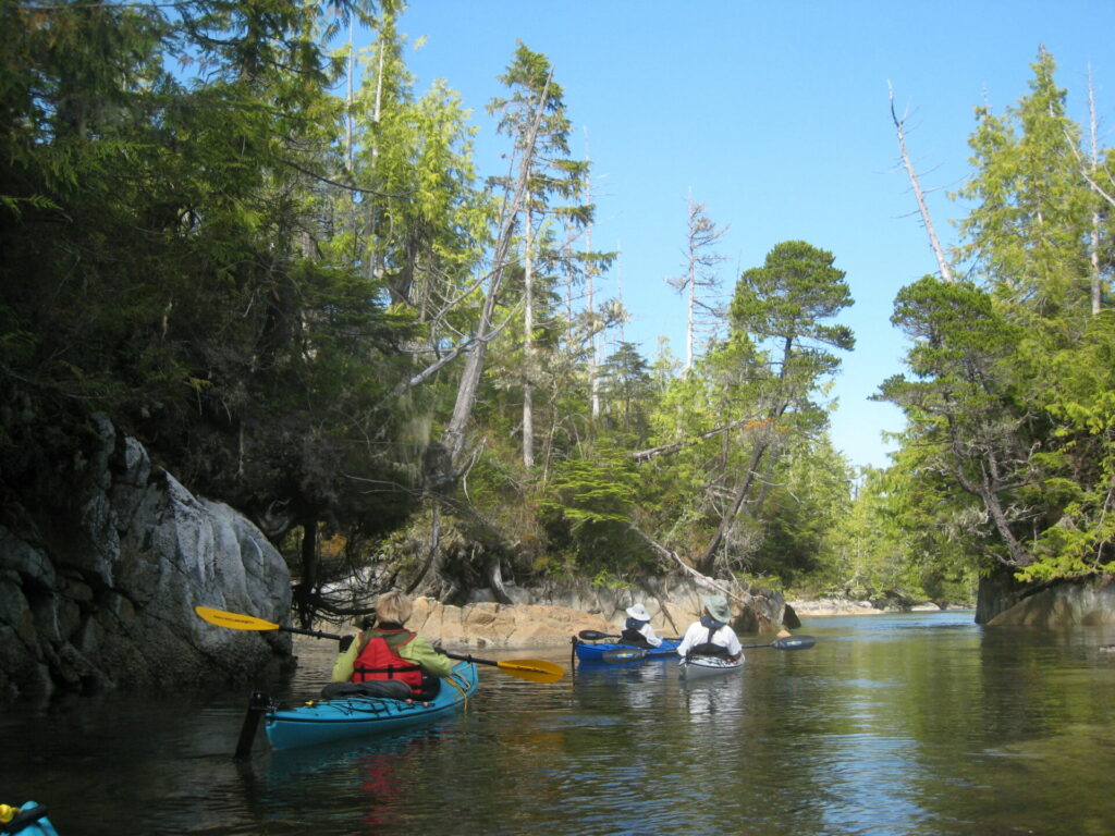
 Paddling into Skull Cove. A very quiet and beautiful spot.
Skull Cove opens into the south side of Bramham Island. Its shoreline is deeply crenulated, with hidden bays and alleys that offer private places of solitude. Much of the bay is shallow, with the east side drying to quite a distance. There is an islet holding a massive midden, the remains of a First Nations village, while on the southwest corner a flight of rickety wooden stairs leads up to an old whale research station where plywood cabins, now derelict, are being absorbed by the surrounding forest. If the path is passable, explore the old shacks and platforms that overlook Queen Charlotte Strait to the west. Not surprisingly, you may spot passing orca or humpbacks, or even the occasional minke.
Bramham Island, by the way (sometimes written as Branham Island, which is easier to pronounce) was named by Captain Pender of the Beaver in about 1866 after Bramham Park, a West Yorkshire estate owned by the Lane-Fox family, a prominent line that boasted a baronetcy, several members of British Parliament, and a High Sheriff of York. As an interesting historical aside, in the 1400s a battle at nearby Bramham Moor decided who would be the next King of England. Quite what the connection was between Captain Pender and the Fox-Lanes seems unclear, but note that the islands just to the north of Bramham are named the Fox Group.
On the west side of Bramham Island lies Miles Inlet, an anchorage that has always charmed and intrigued this writer. Entering from a swell humped Queen Charlotte Strait, the entrance narrows as the side walls rise, and a dead end appears ahead, looking so much like a blind inlet. Let’s have none of that. At the last moment, side inlets to port and starboard open up, the sea’s surface flattens and the skipper relaxes. Anchor in three to five metres (10 to 16 feet) over sand and mud. It’s tight in there, but if stern-tied, some five or six boats can find a gunkhole.
Miles Inlet is a treat to explore by paddleboard or kayak. To the north, a lagoon offers easy access at high water, but by mid-tide a waterfall develops, so time your exploration carefully. The south arm is equally interesting. A sharp right-hand bend in the arm leads you into a silent alleyway, lined with overhanging cedar. Straight ahead, another waterfall develops as the tide turns, draining the estuary to the southwest.
But there’s still more to come! Turn left (south) again and there’s yet another arm that at high tide provides access to a tight squeeze, barely a SUP’s width, which pops you into a narrow, 500 metre long tidal flat, surrounded by marsh that is often filled with wading birds during the summer months. The southern tip of that water is just a short distance from the northern extremity of Skull Cove.
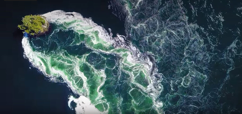 An aerial photo captures the awesome power of Nakwakto Rapids on a spring ebb. Tremble Island appears to cut a wake through the water as it pours across the shallow narrows.
Because of the need to access most of these side coves at high water when the tidal falls are covered, it’s prudent to spend a couple of days here, exploring the ins and outs of this hidden gem. It’s also a good place to wait for better conditions before crossing exposed Cape Caution. When the buoy at West Sea Otter reports less than a metre of swell, it’s time to move.
Bramham Island’s north shore is defined by Slingsby Channel, named for Sir Charles Slingsby, another Yorkshireman. The 10th Baronet of Scriven Park, an officer of the Royal Horse Guards, he was a keen sportsman. While Master of the York Hunt he drowned at a river crossing during a fox hunt, at the age of 45. He died intestate, unmarried, and his hereditary baronetcy died with him.
Slingsby Channel should always be treated with great caution. In the early summer months, massive runoff from the Coast Range funnels through Nakwakto Rapids at Slingsby’s head on each ebb and pours west along the channel. Prevailing northwesterlies blow in opposition, with the result that standing waves form at both the outer narrows (the aptly named Vigilance Point) and the inner narrows (Boot Point). The effect is so pronounced that standing waves can be felt several miles into Queen Charlotte Strait. Boaters bound north or south are advised to stand well offshore, holding the 100-metre bathymetry line as a minimum.
Those wishing to transit Nakwakto and access the more than 1,500 miles of coastline behind those iconic rapids, are advised to approach up Schooner Channel, which carries a smaller flow at ebb, and is sheltered from the northwester. Check and check again the time of slack water, which may last as little as six minutes.
Even at slack, ominous eddies swirl gently around Tremble Island, mid-stream of Nakwakto Rapids. During a spring ebb in May or June, that apparent calm can swiftly morph into 16-knot currents, giving the appearance of Tremble Island moving upstream, throwing a massive wake behind! Treadwell Bay, at the east end of Slingsby Channel, is a good anchorage from which to take the dinghy to watch this awesome display of Nature’s power, while safely out of harm’s way.
When the coast was a busier place, there was a post office and associated community about half a mile east of the Fox Islands on the Bramham Island shore of Slingsby Channel. It served the sizable population who worked inshore on Belize and Seymour inlets. It makes you realize that back in the day, tugs routinely towed log booms through Nakwakto successfully. Even today, I have seen booms anchored to the shore behind the rapids, no doubt waiting to be ‘taken through’ when conditions were right. Rather them than me. Setting up the approach for a slow-moving boom, to hit the gap right on slack, must be a skill few skippers have.