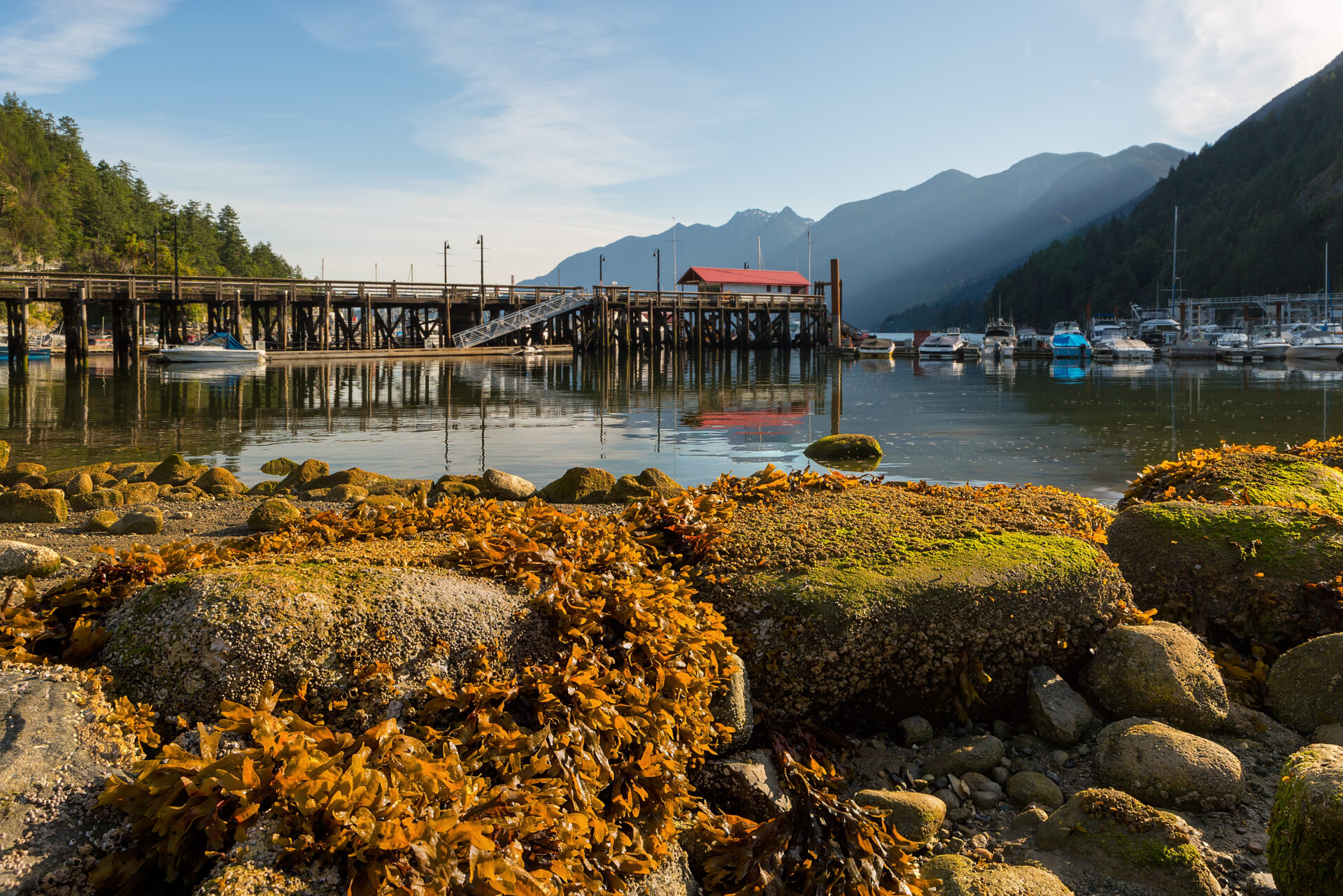

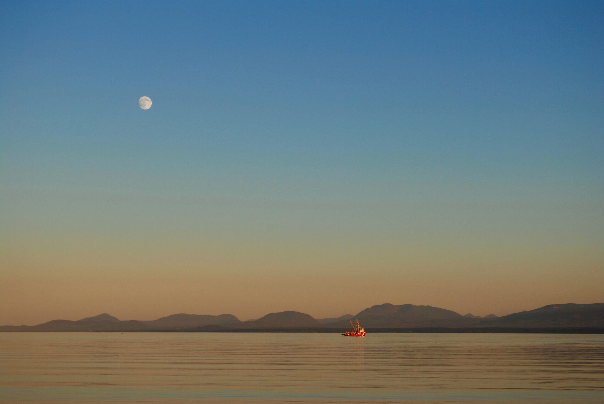
There is a tide in the affairs of man… Well what did Shakespeare know about tides? Quite a bit actually, for his time. Tides taken at their flood (and their ebb) do in fact lead to greater things and after 40 years of cruising the BC Coast, I have grown to appreciate and respect the daily influence of the Moon on the silt-laden and rock-strewn waters of the Salish Sea.
For many boaters, the semidiurnal rise and fall of tides here demands planning that can result in some (or much) apprehension. Other than the Bay of Fundy, BC’s tides are the largest in Canada with currents among the strongest in the world. And, as most school children can confirm, the phenomena of tides are mostly due to our satellite, the Moon.
The leading theory of the Moon’s creation is that the protoplanet Theia, thought to be about the size of Mars, slammed into Earth about 4.5 billion years ago and spun off. After several million years, material from the collision coalesced into what is now our Moon. About 1/4 the size of Earth, the Moon is the largest of all Moons of our solar system in relation to its host planet. Although at times it can look close, it’s a long way away—over 384,000 kilometres (240,000 miles) from Earth. Despite that distance, the Moon exerts a gravitational pull on our planet that is manifested in the rise and fall of water.
Although the Moon started its orbit very close to Earth, it is moving away from Earth at a rate of 1.5 centimetres a year. But its proximity, at least as far as Earth species are concerned, has been nothing but good news. Over billions of years the Moon has deflected asteroids and meteors, stabilized our planet’s rotation and slowed the planet’s spin down to our present 24-hour day. Perhaps as important, the Moon has given our planet life-nurturing tides. From mammals to molluscs—many forms of coastal life find food during the stages of the tides and this includes kelp, eel grass and other plant life.
For thousands of years, mariners have been well aware of the daily tidal fluctuations. In an illustrative example of applying tidal energy to obtain a food source, First Nations people along the British Columbia coast used tide traps to capture fish. Constructed of stone or wood, these traps were put across narrow openings or passes to let fish in at high tide, which were then captured in a pool as the water receded. In Europe, the Celts and the Norse knew all about situating towns far up rivers to stymie invaders unfamiliar with tides. The story of the 11th century Danish ruler of England, King Canute, admonishing his courtiers was actually a tale of his understanding that he had no control over the tides, only nature did.
In the age of square-rigged ships, “tiding over” was a well-known method of working the tides to make progress against contrary south-westerlies along the English Channel. This involved anchoring during the east-running flood and weighing anchor to take the ebb south.
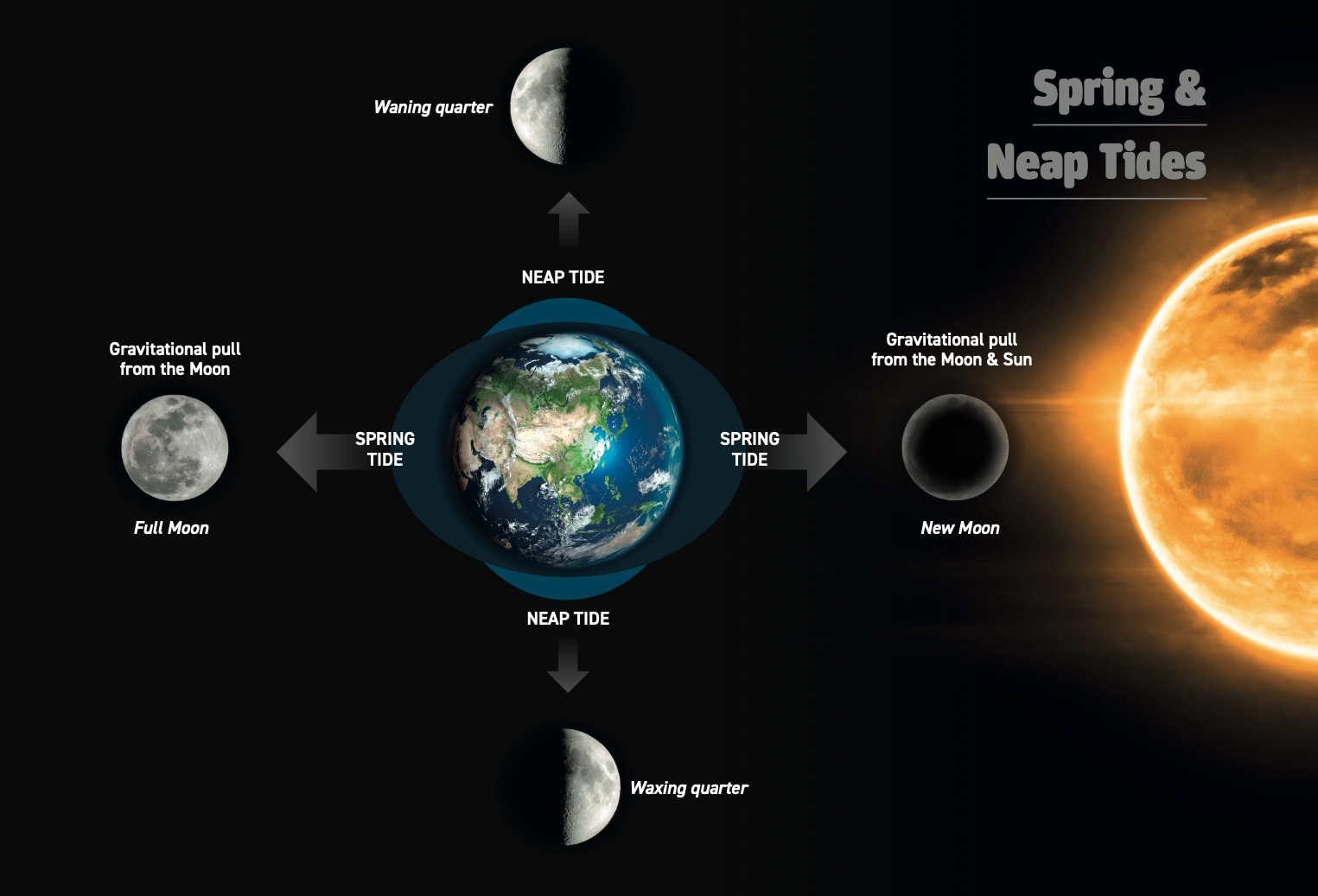
The Moon takes over 27 days to orbit the Earth and just over 29 days to complete all the phases we see. These phases are the different angles of the Moon to the Earth as the Moon completes both its orbit and its rotation. The largest tides, known as spring tides (of Saxon origin meaning “greater activity”), occur twice a month when the Earth, Moon and Sun are lined up. This is at new Moon, when it is between the Earth and Sun, and full Moon, when the Earth is in the middle. Neap tides (again Saxon origin meaning “inactive”) are when the Moon is at ninety degrees (first and last quarter) to the Earth and Sun.
The reason eclipses don’t occur twice a month is that the orbital plane of the Moon is tilted five degrees relative to Earth’s orbit. So, although Earth does not usually cast a shadow on the Moon, lunar eclipses do happen about twice a year. One tip to remember about the phases of the Moon: if the dark area of the Moon is to the left, the Moon is waxing, if the dark area is to the right it is waning.
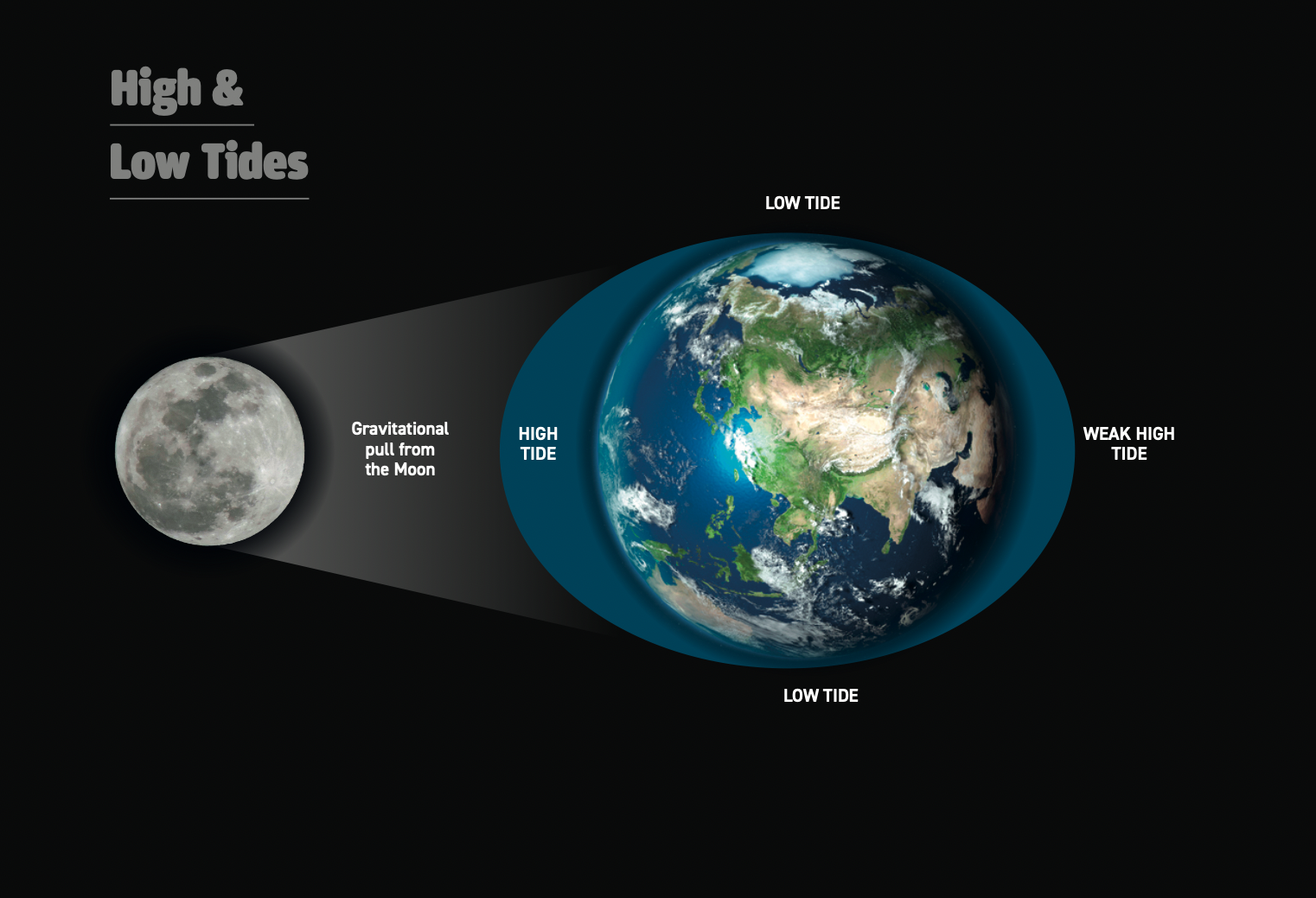
Scientists explain tides as a bulge in the world’s oceans that Earth’s coastlines rotate into. It’s not rising water moving to fill inlets and bays so much as the Earth catching up with this bulge created by the Moon. The main point is that the Moon’s gravitational pull is the primary force on tides. Although the Sun has a much bigger mass, and plays a role in tides, the effect of the Moon is greater because it is much closer to Earth.
However it is viewed, the effects of the Moon and Sun on our tides are complex. Richard Thomson, author of Oceanography of the British Columbia Coast and a scientist at the Institute of Ocean Sciences in Sidney, describes it this way: “On the side of Earth facing the Moon, the Moon’s gravitational attraction at Earth’s surface causes the net gravitational force to exceed that of Earth’s gravitational attraction, causing the ocean to bulge toward the Moon (usually higher high water); on the side facing away from the Moon, the Moon’s contribution to the net pull on the ocean is reduced so the water wants to bulge away into space and this is usually lower high water.” This effect might be compared to squeezing a tennis ball top and bottom—the sides bulge out.
“However, the bulges are not of equal magnitude at each point on the Earth because the Earth’s axis of rotation is tilted by about 23.5 degrees relative to the orbital plane of the Earth. When the Earth is fully tilted toward (or away from) the Moon (during winter or summer solstice) we get a greater diurnal tidal range. When the Earth’s tilt is at right angles to the Moon (Equinox), the ranges of two tides are nearly the same.” As Vancouver boaters can attest, the lowest tides of the year occur near midnight just before Christmas and around noon near the end of June.
Among the many influences on tides there’s also the fact the Moon’s orbit is elliptical. When the Moon comes closer to Earth (known as perigee) it exerts greater influence. If this occurs at full Moon it’s called a “supermoon.” When the Moon’s orbit takes it farther away it’s at its apogee. Other influences such as storm surges, high and low-pressure weather systems and seiches (tidal resonances in coastal basins) also result in tides greater or lesser than predicted. Strong offshore winds move water away from coastlines, exaggerating low tides. Onshore winds push water onto the coastlines, making low tides less noticeable and high tides more pronounced. Moon wobbles, when high tides can become very high and low tides very low, are also historic phenomena and are expected to create some very big tides in the mid-2030s.
Tides, as oceanographers say, are complicated. All that most boaters need to know is we get four tides a day in BC of varying sizes—referred to as mixed semidiurnal tides and the timing is delayed by about 50 minutes each day. Making the most out of tides and currents means timing your trips with the tides. Knowing the state of tide, i.e. rising or falling, makes a big difference in piloting channels and is a precaution in the unlikely event you run aground.
Most chart plotters and charting software come with tide predictions, often showing a sine wave along with tide information. There are also many excellent apps you can download to your phone. My personal favourite is Tide Charts. Using excellent graphics, this free app displays tide information in text and a sine wave as well as giving information on the Moon phases (percent of waxing or waning), weather forecasts with wind speed and wave predictions. Settings allow for metric or imperial.
But if you only bring along tide tables from Canadian Hydrographic Service you can’t go wrong. As of 2021 CHS tide tables are no longer sold as printed volumes; however you can download and print out any tide or current tables you need. (Go to tides.gc.ca). I have used these tables for over 40 years and although apps are great, I still print out the CHS tables. These are arranged in columns with times, currents and heights in black and white and instil confidence—especially when transiting passes. The tables show almost all passes on our coast either as a reference station or a secondary station, with differences in timing and current rates listed below its relevant reference station. The columns show times for turns (meaning slack) to flood or ebb, the time of maximum flood or ebb and the speed of current in the pass in knots. All that’s needed is to arrive at the pass entrance at slack and you’ll have an easy and safe transit.
The duration of slack will vary with every pass. Anything less than five knots means even a slower sailboat should be able to safely transit with a 20-minute window before or after the turn. If the current is stronger than that, I’d try to be at the entrance within 10 minutes of the turn. It’s true some passes can be worked with the local back eddies—Active Pass is one pass where I’m almost always late and use the Mayne Island counter current to work our way west during a flood (our book Best Anchorages of the Inside Passage has more detail). However, some passes have very small windows. Porlier Pass and Seymour Narrows will change very quickly—sometimes even before the prediction. You should also keep in mind that although tides behave like a sine curve (evenly rising and falling) passes do not. Water can get backed up at one end of a pass and at the turn can release quickly. As such, the current through a pass is more like a saw wave and can often reach maximum current less than an hour after slack. Another common mistake with boaters is not adding an hour for daylight saving time for the printed CHS charts.
When travelling within the Gulf Islands or heading up the Strait of Georgia to Desolation Sound, you can use tide reference stations to help map out and time your trip.
For example, Point Atkinson is a reference that covers most of the Strait of Georgia from Sand Heads up to Cape Mudge near Campbell River. The CHS tide tables will include secondary ports on both sides of the strait including Malaspina Strait, which is also referenced to Point Atkinson. If you check which stations or ports are adjacent to your course, you’ll have a pretty good idea of the direction and strength of the currents you will be dealing with on the long stretch from the Gulf Islands to Desolation Sound. Always remember that flood current goes north in the Strait of Georgia (with anomalies near Galiano and Valdes islands) and south for the passes leading to the Broughton Archipelago.
For every pass, my habit is to arrive just as it is turning to positive current—in other words when it is turning to the direction you want to go. Fighting current is tedious and can be dangerous, especially if you get stuck halfway into the pass and can’t get through. There’s been many times I’ve been anchored at Kendrick Island and watched boats in Gabriola Pass trying to buck an eight-knot flood. This is a dangerous pass in which to try and turn around.
If you’ve arrived at a pass going with the current and it looks a little turbulent, such as Seymour Narrows, steer for the darker and more settled water. If the current is quite strong, there will usually be a tongue of dark water in the middle of the pass that is safer than aerated white water where there is less buoyancy.
After 40 years of going through almost every pass on the coast from Victoria to Alaska, I find passes the most exciting and interesting part of a passage. From Nakwakto Rapids (maximum 16 knots) to Porlier Pass (10 knots) to Devils Hole in the Dents (12 knots), all passes provide an interesting education on the power of tides. Respect, like the song, is all they really want.
Stay tuned for Part 2: Working the Tides which will include more specific information on the straits and passes of the BC Coast to Cape Caution.