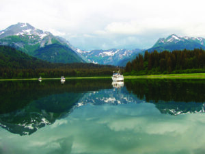
My last article on Wild Alaska in October left you in Juneau with the promise of more Alaskan marvels to come. Here we cruise farther north, up the long fjord of the Lynn Canal, to explore gold rush country and the lively town of Skagway. Glacier Bay lies close by, deservedly named a World Heritage Site in 1992 with its magnificent mountains and eight aqua tidewater glaciers. Opposite, the town of Hoonah is the main ancestral village of the Tlingit tribe.
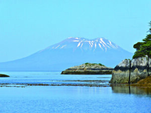
Returning south, one has several options. Should one explore new inside channels or brave the rugged, west coast? A particular lure to the Pacific for us was Sitka, with its fascinating influences—Native, British, Russian and American cultures all come together here.
Whatever the route, you can be assured that the scenery will be stunning, whether it is the soaring, snow-capped mountains plunging into the ocean, dense, green rain forests or the rocky shores of the offshore islands that catch your attention. There will be a plethora of plants and wildlife that are varied and continually captivating. Endless deserted anchorages will beg a stay, along with visits to charismatic communities, whose all-year-round small populations are delightfully Alaskan and off the tourist trail.
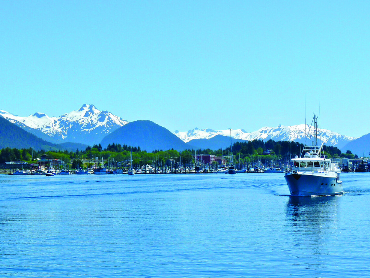
Skagway Skagway lies about 80 miles north of Juneau and you get there via the Lynn Canal, a long, narrow fjord that offers some anchorages and safe harbour in Haines along the way. With mountains soaring to 7,000 feet and high, glistening glaciers, its shores are stunning; but the topography can also cause fierce winds. Fortunately, these are well forecast in a dedicated region on VHF WX. Watch out, too, for the cruise ships that constantly plow these waters. Skagway is the 16th most popular cruise ship destination in the world, and welcomes a million visitors a year.
Although this tourism might be off-putting, Skagway makes an interesting visit, both historically and scenically, and Borough’s Boat Basin is convenient for fuel and grocery shopping, as well as for sightseeing. In 1896, gold was found in the Yukon’s Klondike region. In July 1897, the first boatload of prospectors arrived. More ships brought thousands of hopeful miners who prepared for the 800 km trek to find gold. Within weeks, stores, saloons and businesses lined the streets. Soon the population rose to 30,000 and Skagway was the largest city in Alaska.
In 1898, the narrow gauge railroad began, but by 1899 easily accessed gold was discovered in beach sand in Nome, Alaska, and Skagway’s economy began to collapse. Much of the early history survived, and can be seen in the buildings themselves and in the museum. Seven blocks of Broadway are lined with the old false-front shops and restaurants, and locals in period costumes regale tourists with tales of the past. They call themselves ‘sourdoughs,’ as the original prospectors survived on sourdough bread made from potato water. Now, trips on the railroad show off the magnificent surrounding scenery (sit on the left side of the parlour car if there is no room outside) and you can catch a view of the famous White Pass along the route.
For those into hiking, the excellent trail system will take you to alpine lakes and waterfalls—and the graves of Soapy Smith and Frank Reid, Skagway’s most notorious residents—or on the Chilkoot Trail, a three to four-day hike north along the miners route to the Klondike Gold Fields. Getting exercise is often hard to achieve in the densely forested northern anchorages, so we found having a cleared, sign-posted route is a delightful bonus.
On To Glacier Bay All yachts entering Glacier Bay between June 1 and August 31 are required to obtain a one-week permit—check www.nps.gov/glba/planyourvisit/boat.htm for requirements and regulations. Permits can be applied for 60 days in advance. Twenty-five are issued to private yachts at any one time, of which 14 are given 48 hours in advance. An orientation is required in Bartlett Cove, where considerable useful information is available.
After clearing, we decided to sail to nearby Berg Bay. Although there are shallows at the entrance, the tide was right, a significant factor with a 25-foot range. We spotted several humpback whales, sea otters bobbing on their backs and hosts of birds before we anchored by a small stream—one of the few times the anchor set almost immediately—and searched intently for bears.
While waiting, the park’s literature filled us in on the area’s remarkable history and we learned that there was no bay in 1778 when Captain James Cook, George Vancouver and William Bligh passed this way. Returning in 1794, Vancouver found just an indentation in a massive glacier that was 4,000-feet thick and extended more than 100 miles. Its retreat was one of the most rapid in history and by 1916 Tarr Inlet reached 55 miles from Glacier Bay’s mouth.
Now it is rich in sea life, particularly at the entrance. It has 220 species of birds and 420 species of plants, and of course both grizzly and black bears. Although black bears usually head away from noise, do take bear spray for grizzlies if you’re going ashore.
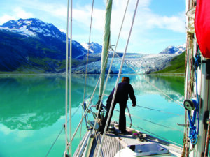
Exploring The Icebergs Glacier Bay has two arms. To the northwest, the larger leads up Tara Inlet to the Canadian border. Branching inlets include John Hopkins and Reid, and other appealing anchorages, so we decided to spend more time on this side of the bay. Two days seemed enough for a trip up Muir Inlet, the other main inlet to the northeast, and a night at North Sandy Cove. Our first day planned was at least 60 miles and we had to leave at 06:00 for the high tide. The current would be with us, which is significant since it runs to eight knots. Heading out, the low hills and forests of Sitka spruce, lodgepole pine and hemlock soon fell behind, replaced by snow-shrouded mountains and several glaciers that are no longer tidewater and are stranded high on gouged, U-shaped valleys. We identified orange-beaked tufted puffins, marbled and kittlitz murrelets, pidgeon guillemots, common and hooded mergansers, surf scooters and more from our bird book, and the great bird watching continued all week.
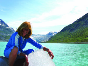
Icebergs come in all shapes and sizes. Depending on the density, much of the berg is under water. On top they sparkle, and those that have flipped over are opaque. Some glow a brilliant turquoise, others resemble sea monsters and dinosaurs, and some are so weird they mock the imagination. It wasn’t until we reached the head of Tara Inlet, with receded Grand Pacific Glacier winding high above, that we really had to slow down for them.
To our left lay Marjorie, a true tidewater glacier whose striated face rises 250 feet above water level and about 100 feet below, and is one of the longest at 21 miles. A deafening boom and the resounding splash of ice calving was a good reminder not to approach too close.
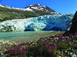
We anchored in Reid Inlet and it remains a favourite. I reveled in the beauty of this small bay, with its perfect glistening tidewater glacier at the head and the multiple Rorschach reflections. The sky was a pale sapphire, the sea aquamarine, the hills were mottled with snow and brilliant green growth, while the glacier flowing down glinted like diamonds, its face glowing from the palest to the deepest of turquoise with hot-pink fireweed in front.
We hiked the trail on the north side that was full of birds, like the red-beaked black oystercatchers whose golden eyes watched us unconcerned, and considered kayaking to the face, safe from calving as the glacier is only tidal at high tide. Could anything else match this spectacle? Surprisingly, it could.
When we headed north around the headland, we saw Lamplugh, one of the two advancing glaciers, and the magnificent John Hopkins, which has a mile-wide face and towering, snow-covered peaks rising sharply behind. Part of the Fairweather Range, they rise to over 6,000 feet with Mount Fairweather, named by Captain Cook, standing at 15,320 feet. And so our week continued with more magnificent glacier memories in Riggs and up Muir Inlet.
Hoonah Across from the bay on Chichagof Island lies Hoonah, the village by the cliff. This is the largest town of the Huna group of the Tlingit, “the people of the tides,” who have lived in the region for thousands of years. The town’s mainstay from 1912 to the early 1950s was a large salmon cannery to the north of town. After being abandoned for years, the Huna Totem Corp, a local Native organization, bought and restored the facility and created a private cruise port called Icy Strait Point. It now houses a cannery display line, museum, shops with local arts and crafts and restaurants. A cultural and wilderness centre gives a taste of traditional Tlingit culture, with dramatic native dance performances and local wildlife excursions. If that is too tame, a zipline, that claims to be the world’s longest and highest at over 5,300-feet long and 1,300-feet high, is nearby. For boaters, Hoonah offers a convenient marina in the town of about 1,000 residents, and excellent haul-out facilities with a 220-ton travelift.
Heading South Whether to go inside or down the ocean side will be a decision when heading south. Although enjoyed by friends, we reluctantly gave small, pretty Elphin Cove to the west on Chichagof Island a miss and instead headed down Chatham Strait and west to Sitka through Peril Strait. En route, we were privileged to see five humpback whales—blow, dive and then come up bubbling for their herring prey—not once but four times. It was so magnificent to witness and so hard to photograph! Do take two camera batteries and keep them charged. We also stopped at Funter Bay, on the Mansfield Peninsula, for the night, which has one of several free state docks and we bartered with local fishermen for halibut and salmon.
Despite its name, Peril Strait was unbelievably benign and we sunbathed on the foredeck surrounded by glistening, snow-capped peaks much of the way. Be warned, the local tide tables given out for free by many stores do not include current information for Sergius Narrows. Once through and into the Pacific, perky sea otters surrounded us, paddling away with their big feet, smiles on their teddy-bear faces.
The people in Sitka are endlessly friendly and welcoming. We loved the mature but frontier ambience of this fishing town, and that only Lincoln Street had tourist emporiums, and tastefully disguised. Strategic Tower Hill enlightened us about its history, from the Russian battle with the Tlingit in 1804 to the Americans buying the region, 586,412 square miles for $7.2 million, in 1867. The museums, such as the Sheldon Jackson, are complex and beautifully presented. The National Historic Park’s totem trail is a must and the old churches show a poignancy of eras. We even experienced a service in the replica of St. Michaels Cathedral, a Russian Orthodox church.
Our voyage down the Pacific coast of Baranof Island was turbulent, as the Pacific swells bounced off the rock-strewn coast. With strong southerlies building, after visiting Hotsprings Cove for lunch we found shelter by the Yamini Islands for the night, thankful for the calm waters but setting the anchor with care as williwaws whipped through the bay.
We departed in the typically lighter winds the next morning and, after rounding the southerly point, headed into the delightful Port Alexander, another highlight. Around the bay lives a small, year-round community of committed people. As we wandered the typical boardwalk, everyone had a friendly greeting and we were delighted to meet the three students who had just graduated from the small school, all thrilled to be going to Juneau to college next year.
The king (our spring) fishing season had opened early and there was excitement in the air, with fishing boats frequently coming and going. There were also the town’s supply vessels. Goods were unloaded on the dock—a mix of food, building or garden supplies and other sundries—amazingly quick and just as swiftly everything was removed, mostly in dinghies from around the bay.
Entering Canada It was now time to head south as the fog was beginning to roll in, which made progress tiring until it lifted, generally around noon. We headed back inside, enjoying several more stops before returning to Canada. Although tempted to visit Haida Gwaii, with the weather so favourable, we decided to continue to Dundas Island (where we were swarmed by blackflies) before clearing-in back into Canada as required in Prince Rupert. The mileage had been huge, the days long, but our Alaskan experiences were so rewarding they were worth every minute on watch.
Trip Planning As fog is likely after June, particularly on the outer coast, most cruisers head north in May. The weather is unpredictable and radar makes life safer whether the poor visibility is due to fog or rain.
To cope with the cool winds, cockpit enclosure panels on the bimini are a recommended addition for sailboats. We found it could become so warm inside our “greenhouse” that it was quite a shock to go out on deck! Below, a cabin heater is a must, along with a 110-volt unit to use when plugged in at the dock. Floorboards will be cold, so use a carpet or slippers, but the fridge won’t have to work too hard.
Sailors should be prepared to travel long days, often motoring and waiting on weather, particularly when going to the west coast. The Pacific Ocean swells can be uncomfortable, particularly from the backlash from the shore, making many who visit Sitka use Peril Strait to minimize the ocean distance.
Most cruisers will cover 3,000 miles when cruising to Alaska from the Vancouver/Seattle region and take at least three months.
Stocking up on essentials and self-sufficiency are essential. Tide and current tables and paper, in addition to electronic charts, are a given. Cruising guides are useful. Check out Northwest Boat Travel—Washington, B.C. and Alaska, 2015, Exploring Southeast Alaska, Dixon Entrance to Skagway, 2nd Edition by Don Douglass and Réanne Hemingway Douglass. Also, Charlie’s Charts, North to Alaska by Charles and Margo Wood—although old, has some useful tips
Make sure to apply for a permit to cruise in Glacier Bay, 60 days in advance of your trip. Finally, check your insurance and medical coverage, and think about the types of communication tools you’ll need to connect with those back home. And don’t forget your passport and boat documents.