
Nearly two and half millennia ago, Hippocrates, the father of modern medicine, observed that “walking is a man’s best medicine.” Not much has changed since then. Walking is so good for you, on so many levels, that it’s a wonder more people don’t do it more often.
OK, bikes, cars and buses have cut into the market, but the reality is there’s a reason why half of your body is given over to a pair of limbs specifically evolved to get you from A to B. And until the invention of the combustion engine a few generations ago, almost everyone walked everywhere. Shank’s Pony, they called it, and we’ve been doing it ever since we swung down from the trees 50,000 generations ago.
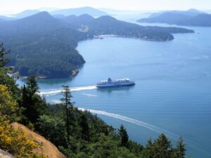
Boating is by nature rather sedentary, so it’s important to stretch those legs periodically and change the view. Here are another five hikes—most easy, a few challenging, all within the Gulf Islands area, where a little effort produces exceptional rewards. As the canny Scotsman John Muir put it in the 19th century, “Thousands of nerve-shaken, over-civilized people are beginning to find out that going to the mountains is going home.” He might well have added, “Aye, and it’s free!”
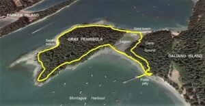
Gray Peninsula From Montague Harbour
Elevation gain: Negligable
Distance: 2.5 kilometres
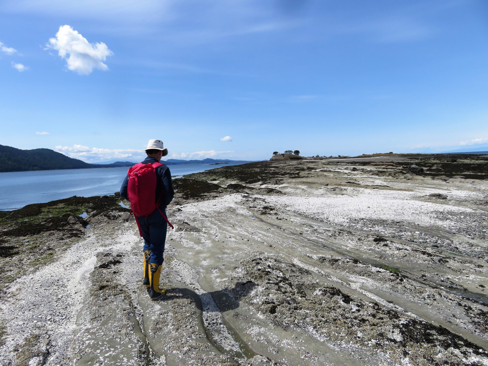
 There’s an attractive beach on the outside of Gray Peninsula that is best appreciated at low tide.
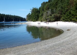
This is a gentle walk with interesting history and geology, plus white shell beaches galore. It’s best done at low tide to get the most out of the beaches. Anchor in Montague Harbour and come ashore at the Montague Harbour Marine Provincial Park dinghy dock at the north end of the basin. Take the stairs down to the beach at the end of the jetty and follow the shoreline under the jetty west toward Gray Peninsula. It’s separated from the main island by an ancient midden/beach that traps a small lagoon inside it.
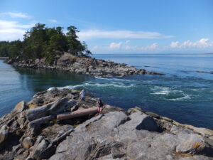
Up the bank onto Gray Peninsula, turn left and follow the coastline along a broad path overlooking the boats anchored in the harbour. There’s a fine bench at the southern tip where you can linger to admire the view. Continue clockwise, dropping down onto the white shell beach that runs up the outside of the peninsula, overlooking Parker Island. Garry oak and arbutus overhang the shore.
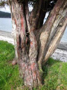 A rare Pacific yew grows on the dike connecting the north side of Gray Peninsula with Galiano Island. In times past the bark was used in medicine.
At low tides, tilted beds of sandstone are exposed amid the beaches, formed 80 million years ago when Vancouver Island collided with North America. Huge mountains were thrust up on both sides of the strait, and as these peaks eroded, layers of sand, silt and cobbles were deposited as sedimentary rocks in what is now the Strait of Georgia. It’s all there to see, like the bones of the earth.
Follow the north beach back onto main Galiano Island. The path is on a dike that forms the north end of the salt lagoon. Midway along the dike, a rare pacific yew tree stands, not very tall, with flaky bark that shows subtle hints of pink and purple. Until recently, yew bark was harvested to make the cancer-fighting drug Taxol. (It’s now synthesized.) Return to the dock via the campground under the trees.
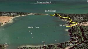
Winter Cove & Boat Passage
Elevation gain: 20 metres
Distance (return): 3 kilometres
Winter Cove, encircled by Saturna Island to the southeast and Samuel Island to the northwest, is justifiably popular with cruisers. A sandy bottom between five and 10 metres with good holding, and enough space to anchor the US Navy are reason enough to visit. Sheltered from southeasters and all right in moderate northwesters, it’s a favourite on so many levels.
There are fossils on the Samuel Island beach facing the cove (the property above tide line is private and should be respected). In the middle of the anchorage, the 67-year old schooner Robertson II foundered on the only rock in the basin, on Canada Day 2007, and was stripped and scrapped. Its position is shown on charts—skippers beware.
 Boat Passage connects Navy Channel with the Strait of Georgia. During the strong floods (shown here) and ebbs, the water races through this 20-metre-wide slot.
The forested slopes of Mount David and Warburton Pike provide a scenic backdrop during your stay. The latter, at 401 metres, is the highest peak in the Gulf Islands. If you’re into peak bagging, ask at the general store next to the ferry terminal how to find the road that curves up its north side. It’s six kilometres through forest all the way (a boon on a hot day). Only at the last moment do the trees thin and suddenly you are presented with panoramic views over the surrounding Canadian and US islands. We’ve ridden bikes up a number of times. The uphill is a grunt, but the descent is a treat!
If your hiking ambitions are less summit-orientated, the walk out to Winter Point on the east side of Boat Passage is well worth it. Land at the public jetty and follow the signs past the picnic tables, tracing a well-beaten path through the trees. Winter Point is one side of the gate that controls the powerful flow through the narrows.
On a spring tide, the 20-metre-wide chute is a boiling raceway. Like Skookumchuck Rapids on the Sunshine Coast, time your arrival to coincide with a tidal high or low for the most impressive views. The flood sets northeast into the Strait of Georgia, the ebb southwest into the cove. Although deep enough for large vessels (seven metres at LLW means there’s lots of clearance) few people take the gap, even at slack.
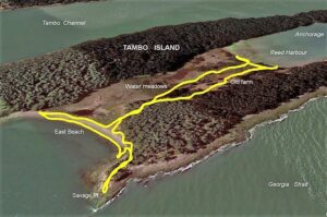
Tumbo Island
Elevation gain: Negligable
Distance: 2 Kilometres
Anchor at Cabbage Island on marine park buoys or over good holding in five to 10 metres. Tumbo Island, just east of the anchorage was farmed for many years, but was absorbed into the Gulf Islands Marine Park in the 1990s, and today is a gem of a place to explore. Land at the back of Reef Harbour Bay (it gets shallow) near five large white-trunked poplars. You quickly discover you’re not on a beach, but a dike that seals the west end of a lagoon.
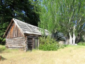 The old farm buildings on Tumbo Island still stand, although they are all part of the Gulf Islands Marine Park now.
Heading inland (east) there’s a trail that leads by the water-filled meadows with reeds full of red-winged blackbirds, past old farm buildings lovingly built in days gone by. The chicken house is a miniature barn, constructed with a keen eye to detail and whimsy.
At the east end of the lagoon, turn north if the view appeals and walk out to Savage Point, a misleading name for a sandstone headland that juts out at the northeast corner of Tumbo. Or take the beach south, admiring the snow cone of Mount Baker in the distance at nearly 3,300 metres—the highest peak in the Pacific Northwest. Turn west again and follow the meadows back to where you landed on either the north or south side of the wetland.
St. John Point on Mayne Island
Elevation gain: Minimal
Distance: 1.6 kilometres
The southern tip of Mayne Island, overlooking Saturna Island and Georgeson Passage, is a recently created park that offers scenic hiking along the forest edge above the shoreline. In 2017 the island residents raised over two million dollars to buy back the 26 hectares that make up the iconic headland of St. John Point. We should all be grateful. There are few walks that deliver such a plethora of iconic arbutus trees with their red peeling bark and smooth avocado inner trunks.
This is one of those hikes where you can do as much or as little, as the mood takes you. If you’re a serious hiker, you could anchor in Horton Bay off Georgeson Passage (keep out of the current that pumps through the channel. If in doubt, anchor close to the locals—they know) and tie up the dinghy at the public dock. Follow Horton Bay Road south to the park boundary (one kilometre).
Alternatively, anchor in the last small indent on Mayne Island in Navy Passage before St. John Point, known locally as Kadonaga Bay. There’s room for a boat or two, and the bottom is sticky mud. There are three rather grand houses up slope on the north side, but the south side of the bay is where the park starts, and the coast path begins there. Head south above the shoreline.
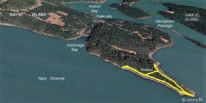
Still another option is to anchor in Winter Cove or Irish Bay and bring the skiff across to land between the two cables on the southeast shore, about 300 metres from St. John Point. Pick up the trail above the beach, and follow it through tall Douglas fir, juniper, cedar and low salal, always with fine sea views. There are strategically placed benches that encourage you to stop and linger.
The path forms a narrow V with St. John Point at its base. Rather than return along two sides of a triangle, you can cut back across the low ridge to avoid repeating what you’ve already hiked. There’s no official trail on the cut back; just choose a deer track. The understory is open, with minimal salal on the east side. Or return by the same trail you came, along the shoreline.
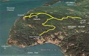
Mount Galiano from Montague Harbour
Elevation gain: 275 metres
Distance: 5.1 kilometres
This route involves four kilometres of approach road in each direction, so unless you are willing to add an extra two hours to your hike, it’s best either to rent a moped in Montague Harbour from Galiano Adventures, or try your luck hitchhiking. This latter choice is not as challenging as it sounds. Gulf Islanders march to a different drumbeat, and only once have we ever had a car pass without stopping. It has become so normal to expect the first car to pull over, that our criterion is not if it will stop, but how interesting is the driver? We are seldom disappointed. Island folk are fascinating and tell the most entertaining stories.
Montague Road runs from the marina for about three kilometres to merge with Georgeson Bay Road on the right. From there it’s a 100-metre walk on Georgeson Bay Road to a right turn onto Morgan Road. Follow Morgan as it climbs past a few widely spaced properties, and a hundred metres past where it turns to gravel look for Lord Road. It’s well signed, as it’s a popular start of the climb to Mount Galiano. The trail is obvious but narrow, climbing steadily until it merges left onto an old road. Follow the road about 200 metres as it descends slightly left, and look for a broad track leading uphill on the right, that takes you through cool forests to the top.
 From the lookout point on
Mount Galiano there’s a panoramic vista below as ferries emerge or disappear into Active Pass.
An alternative to the Lord Road route is to continue along Georgeson Bay Road until near its end, where Active Pass Drive leads up right to the Mount Galiano Park car lot. Again, it’s well signed. Follow the trail uphill. This track is gentler but longer than the Lord Park trail, and has the disconcerting habit of meandering across slopes and even going down slightly, which can be slightly unnerving when you want to go to the top. The two trails merge about half way up, and there are plenty of mini-signs along the way.
About three quarters of the way up, a pile of aluminum pieces, which must once have been a plane, are passed next to the trail, and the source of all the park signboards. Nothing is wasted on the Gulf Islands.
The track leads to a spectacular viewpoint that is not at the true summit but on the lip of a steep grass slope that overlooks Trincomali Channel and Active Pass. Almost under your feet, ferries emerge and disappear, while the view over the southern Gulf Islands is a knockout. Linger, and enjoy