

We departed Vancouver Harbour on an early spring morning headed west-northwest. Our destination was a lesser-known anchorage on the Sunshine Coast: Frenchman’s Cove.
The sun was out and a nice southerly breeze kicked a small chop in English Bay as we made our way out into the Strait of Georgia. Once past Point Atkinson we kept a constant lookout for logs and deadheads on the surface as a strong spring freshet had filled the waters off Howe Sound with debris. We picked our way carefully through the turquoise-coloured water, our white sails contrasting nicely against the azure-blue sky overhead.
The currents along the stretch of the Sunshine Coast from Gibsons to Roberts Creek and up to the Thormanby Islands can be challenging, with a strong backeddy running northwest against the prevailing south-flowing ebb in the middle of the strait. We rode this backeddy up toward Halfmoon Bay, making good time to our destination and arrived at the rock-strewn entrance to Frenchman’s in the early afternoon.

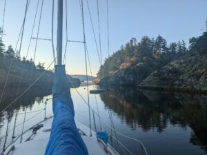
Frenchman’s Cove is accessed via two narrow channels. The favoured (southern) entrance lies between Jeddah Point and a cluster of rocks just to the north. Stick to the middle of this channel and keep the large, round rock (lying about halfway along this channel) to starboard as you slowly enter the first inner basin. If you enter through the northern passage (not recommended), favour the northside both coming and going. Whichever route you choose, keep a lookout on the bow and go slowly.
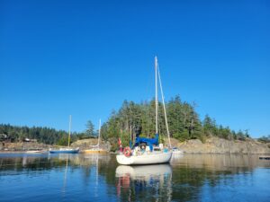
There’s good protection from all but the strongest southeast winds and room for three or four boats in this first basin—as long as everyone runs a stern line. When we arrived we were surprised to find a small floating dock belonging to the “Welcome Pass Yacht Club” (WPYC) took up much of the prime anchoring territory on the south side of the cove. A long makeshift dock—made from floats and logs lashed together—occupied the northern shoreline of the anchorage. Two pretty sailboats and a well-kept classic cruiser occupied this “dock” and when we arrived a woman was hanging her laundry along the stern rail to dry in the afternoon sun.
We considered tying to the WPYC “outstation” dock, but instead dropped the hook in the western corner of the first basin in about three metres of water and took a stern line to the southern shore. With the anchor down and the boat secure, it was time to launch the dinghy and explore the anchorage, including the inner basin.
A short dinghy ride through a winding, tree-lined passage leads through the second basin (overlooked by private residences and their docks) and then through an even narrower channel into the inner basin. This inner sanctuary dries at low tide, but boaters willing to spend a day or night on the mud will find secluded protection from all weather here. This section of the bay is part of Smuggler Cove Provincial Park with the popular (and often busy) anchorage of Smuggler Cove just a few hundred metres across the forested peninsula to the northwest.
The upland around most of the anchorage is private property, and “no trespassing” signs should be respected. After our reconnoitre around the cove, we rowed back to the boat just in time for cockpit hour. We set ourselves up in the cockpit with our favourite drinks in hand and watched the sun make its transit high above the 50-foot cliff wall lining the south shore. Before long, a small deer appeared on the beach tucked deep into the cranny where we had dropped the hook. The sounds of kingfishers flitting overhead and seals surfacing in the narrow entrance of the cove made for a delightful evening.
The next morning, we rowed over to the rocky beach where we had spotted the deer the day before to stretch our legs—no sign of any deer this morning. Then we rowed to the small isthmus on the south side of the cove. We hadn’t noticed this narrow passage the day before. It was dry when we arrived and appears to only run with water on the highest tides or during storm surges. Alternative anchorage can be found in the small indentation on the outside of this isthmus, between Jeddah Point and the islets lying just offshore. Anchor here only in settled weather in five to 10 metres of water.
After breakfast we weighed anchor and made our way carefully past the ominous rock guarding the entrance and out of the anchorage. Once clear of the islets off Jeddah Point we pointed our bow northwest for destinations in Desolation Sound. Au revoir Frenchman’s Cove!

When you go
Location: 49°30’21″N 123°56’53″W
Nearest marina: Halfmoon Bay Pier
Buccaneer Marina
Secret Cove Marina