It was a bizarre idea. Pleasure vessels—other than the occasional canoeist—simply don’t travel the length of the Mackenzie River. At over 1,700 kilometres it’s the longest in Canada. It flows north through one of the largest wilderness areas in the world before spilling into the Arctic Ocean. Its extensive drying flats and sandbars shift throughout the ice-free season from May to October. The few isolated villages, mostly from the Dene and Inuvialuit nations, are typically hundreds of kilometres apart with little sign of human presence elsewhere. In places, striking high bluffs and dry distant mountain ranges frame the river but mostly the shoreline is low and monotonous and lined with spruce and willow trees. More black, grizzly and polar bears, plus caribou and muskox inhabit this region than humans. Hungry hordes of blackflies, mosquitos and no-seeums can drive a person insane.
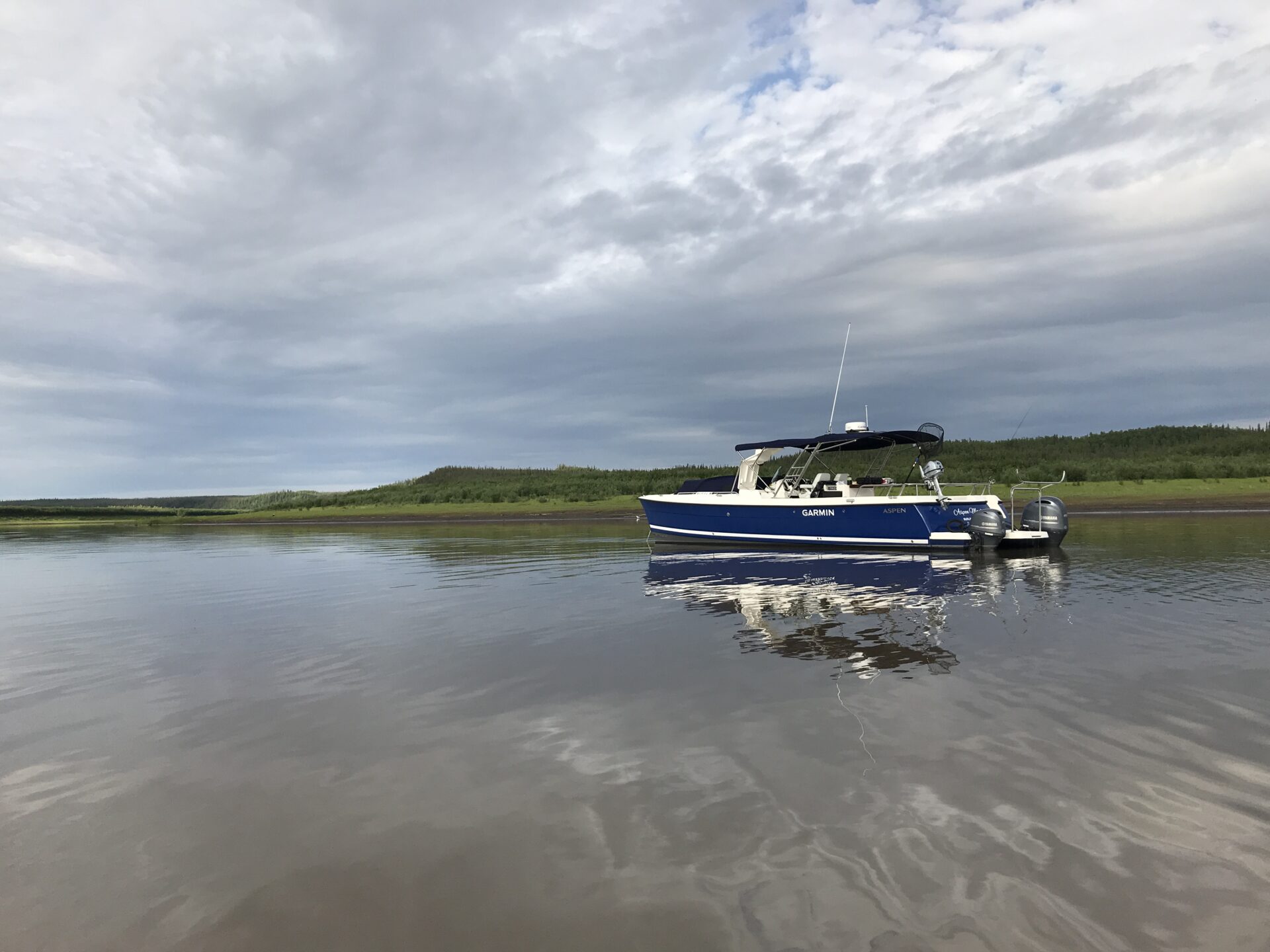
 Rigged and ready to go!
The only commercial vessels are a handful of tugs and barges that make a couple of trips up and down the river each season delivering supplies. The river is only navigable by vessels with a maximum draft of 1.4 metres. Each year after ice-off, the Canadian Coast Guard identifies the best navigable channel and places some 700 can buoys, realigns range markers and repositions the aids throughout the season due to scouring and siltation that constantly change the navigable channel.
There are no electronic charts for the river, which was last surveyed 20-something years ago and as a result, the depths shown on the 26 paper charts of the river are not trustworthy.
PREPARATION
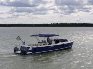
Larry Graf is the founder of Burlington-Washington-based Aspen Power Catamarans. His idea was for the two of us to tow his new open, outboard-powered 34-foot catamaran—appropriately named Arctic Adventure—1,700 kilometres from Washington through BC, Alberta and the Northwest Territories to Great Slave Lake. We’d launch, say our prayers to the river gods and hopefully make it down to the Arctic Ocean in eight or 10 days. It wouldn’t be a leisurely cruise as to minimize his time away from the Aspen factory, “Nonstop Larry” wanted to be on the move every day, stopping only to refuel and to sleep.
Graf’s full displacement power catamarans to 40 feet are unique in that they are proas, with one hull 35-percent narrower than the other. This slim profile requires less propulsion (and therefore less fuel) when compared to a regular catamaran—and 50 to 60 percent less than a similar size planing monohull. A 200-horsepower Yamaha powers the wider starboard hull while a 70-horsepower Yamaha on the port hull provides the proper balance. With a draft of only 31 inches (21 inches with outboards at half tilt) the 34 is ideal for the Mackenzie. Its range, with a combined fuel capacity of 120 gallons in the tanks and 50 gallons in reserve, would be about 560 kilometres, another essential factor considering we were uncertain where, if and when we could obtain fuel.
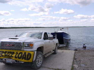
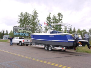 The total length of our rig was 60 feet and required a wide load permit.
ON THE ROAD
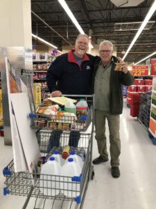 Stocking up at the Northern Store in Hay River.
We left Washington in late June. It took us three, mostly uneventful, days towing the boat through some spectacular Rocky Mountain scenery to reach Great Slave Lake. After overnight stops at Valemount and the town of Peace River, we passed into the Northwest Territories and arrived at Hay River during an unexpected storm with horrific rain and winds gusting to 60 knots. We drove to a beach where we stared, slack-jawed and wide-eyed at the seething mass of frothing waves on the shallow lake. Not good. What had we gotten into? There was no way anyone could venture out in those conditions.
ON THE RIVER
DAY 1: Unable to enter the river via Great Slave Lake, we stop at the Hay River Coast Guard base where we learn that for the past few weeks, since the river ice melted, the two buoy tenders, Eckaloo and Dumit, had been searching out the best navigable route, realigning the many range markers and replacing the hundreds of red and green can buoys they had removed before ice-up. That work wasn’t yet complete, and that was good cause for unease.
 After three days of driving, we splash the Arctic Adventure at Fort Providence.
We go to Plan B: Larry makes some calls and learns that we can launch at Fort Providence, at the head of the Mackenzie. It is blowing hard as we drive over the only permanent bridge on the river. Below us, the wide, muddy, windswept river is daunting. I wonder what I’d signed on for and I’m sure Larry is feeling the same trepidation.
At Fort Providence (population 700), we fuel up, purchase a few last-minute provisions (six beer for $24), then make our way to the boat launch. With the wind still blowing at about 20 knots, Larry gets us launched safely and we tie up against a battered sheet-steel piling to set up the canvas and load our supplies (which includes my .303 rifle for protection). The river is so shallow here that the wave action keeps our big outboard banging onto the rocky bottom, but we have no alternative.
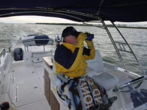 Spotting far-away buoys required constant vigilance.
It is late in the afternoon when our local contact, Chris Mitchell of the Big River Service Centre, drives Larry back from the storage yard where he’ll keep the truck and trailer. We are advised to head straight out from the launch ramp to the first red can buoy, then make a right into the main channel. Sounds easy, but we come within a foot of running aground twice and have to dodge shallows before reaching the main channel. We breathe easier and begin following the can buoys downriver. Not an auspicious beginning.
 We named my station at the chart roller Wilson, after the Tom Hanks movie “Cast Away.”
Our paper charts have been trimmed and taped together on rollers and fitted into a box that will allow us to scroll our way downriver. This is the system the Coast Guard and tugs use to navigate the river. The print-on-demand charts, though updated the previous year, are not completely accurate due to the constantly shifting riverbed. Without electronic charts, Larry has installed a Garmin TOPO map chip into our Garmin chart plotter. A topographical map is a poor substitute for a navigation chart, and it shows only the outline of the shore (from about 10 years ago) and what was wet and what was dry at that time. It isn’t ideal and throughout the trip we were constantly travelling over top of what had once been sandbars, islands and even the shoreline. Topo maps don’t show depth, but at least we could lay down a GPS track.
 The current was fast and relentless.
We quickly develop a routine where Larry drives and I stand behind him at the chart box suggesting where to look for the next buoy. Both of us use binoculars and strain to spot the “next” buoy, whether red or green. We make it about 80 kilometres before anchoring at 20:00 just off the main channel in 30 feet of muddy water. After months of preparation, we are on the river at last! However, any satisfaction is tempered by apprehension about what lies ahead. The wind has finally died and the only sound is the current burbling gently past the transom. The tree lined, gravel shore is low and not particularly interesting. The sky is big and overcast, with bands of rain in the distance. We spend the rest of the evening sorting gear, inflating the dinghy and scarfing down cold ham and potato salad (which became a staple).
DAY 2: We get underway at 07:30 and settle into a comfortable cruising speed of about 18 knots. When combined with current, our average speed over the bottom is closer to 21 knots (and sometimes as high as 27 knots). The outside temperature is a reasonable 20 degrees, but at speed, against typical headwinds blowing up the river, the apparent wind is blasting us at about 40 knots, and forces us to bundle up in heavy raingear, wool hats and gloves. Navigation is becoming a bit more comfortable and we’re getting used to spotting the buoys, following range markers and constantly watching the sounder, however, it takes every bit of our concentration to navigate.
After 300 kilometres, we arrive at Fort Simpson (population 1,200), at the mouth of the Liard River. We have arranged for a fuel truck to meet us at the Cooper Barge terminal. We tie up next to a beached tug (there are no permanent docks on the river due to ice) and are met by Mike Cooper and his brother and cousin, part of four generations of Coopers who have been towing on the river since 1942. Mike gives us valuable advice and suggests a couple of safe overnight stops. We depart in late afternoon and cruise another 130 kilometres before tucking into a quiet and picturesque backwater behind an island at Camsell Bend. In the distance, bald mountains rise 5,000 feet to frame the skyline.
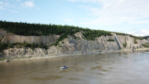 Impressive cliffs just south of Norman Wells give a sense of scale.
DAY 3: We sleep better after lighting a citronella candle, dousing ourselves with bug spray and sealing holes in the canvas. We also use the diesel forced air heater to keep the chill off for the first time. We wake up to still air, full sun, blue sky, birds chirping. Around us there is absolutely no sign Sans Sault Rapids of civilization. We’ve travelled 430 kilometres so far and have managed to avoid running aground, though the depth has frequently been less than 10 feet and sometimes as little as four feet. This is something we will have to get used to. It’s a big contrast from tidal waters.
In the early afternoon, we come across a canoe being paddled by two weather-hardened women. They’d been on the river for 17 days from Fort Providence. We stop to chat and leave them with gifts of cold beer and a couple of precious cookies baked by Larry’s wife.
We nose into shore and drive our bow onto the gravel beach at the small village of Wrigley (population 100) and unload our jerry cans. A local woman gives us a ride in her pickup to the fuel depot, which is only open for a couple of hours a day. When the attendant arrives he can’t get the pump working. He gives us a lift back to the boat, while his hunting rifles bang into my legs in the back seat. Like most small communities we visit along the way, there’s a prominent white steepled church, the homes are somewhat ramshackle and a number appear abandoned. He explains that due mostly to the lack of jobs in the small villages, many residents must move elsewhere or rely on hunting, trapping and fishing to supplement any social assistance they may be receiving.
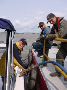 The crew at
Cooper Barging in Fort Simpson
helped arrange for a fuel truck.
Fortunately, we still have enough fuel to continue on, so we back off the beach and head downstream. At 10:50, we anchor for the night off to the side of the main channel, where we’re held in place by the steady current. Another cold ham dinner and while enjoying an after-dinner scotch, we realize it is 01:30, though it is still light. We are definitely in the land of the midnight sun! We’ve now come 680 kilometres from Fort Providence.
DAY 4: We awake to steady rain and a 15-knot, opposing, north wind. We make coffee, bundle up, fire up the outboards and get underway. The combined boat and wind speed are 35 knots; my cereal and milk are blown right out of the bowl. Mile after endless mile, I’m surprised at the lack of any garbage lining the shore of these pristine waters and the absence of the ever-present clearcuts that define coastal BC. At one point we stop to observe a small black bear foraging along the shoreline, our first sign of wildlife.
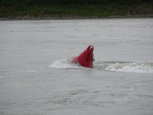
Speeding down the river has become like a slalom ski course. We fly along at well over 20 knots and marvel at the power of the current pushing us relentlessly downstream. In high-current sections, the red and green buoys are half submerged and trailing long frothy white wakes. It takes all of our concentration to avoid trouble. Should we hit one of those buoys at speed, we could be destroyed. Every time the shallow water alarm goes off, we tense up and immediately stop. However, with the current behind us, it’s not like we can really stop. Typically, we must use half or full reverse throttle to back off shoal areas.
We pause offshore from the tiny village of Tulita (population 475). Excellent cell service is one thing that all these villages have in common. We drift while catching up on emails and sending photos and progress reports for posting on Aspen’s website. We decide we still have enough fuel to press on to the larger community of Norman Wells, where Larry is trying to arrange for a fuel truck.
Oil has been the mainstay of Norman Wells (population 775) since about 1920 and today half a dozen artificial drilling islands dot the shallow harbour (which averages about eight feet in depth). From here the crude oil is pipelined to markets in the south. The sky has cleared and we enjoy the warm sunny afternoon.
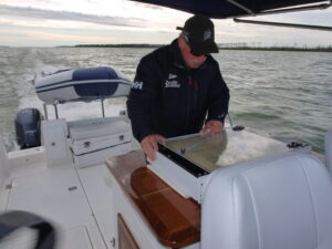
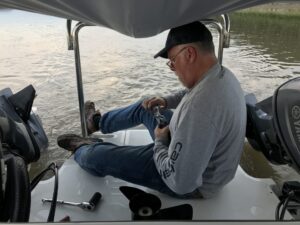 Larry swaps out the prop on the 200-horsepower outboard.
Crew boats zoom back and forth between the oil rigs, and locals are launching their small runabouts for an afternoon on the water. We dock at a steel barge pier and wait for fuel to be delivered. Meanwhile we wander ashore and get a few more groceries. After fuelling up, we decide to press on and find a quieter place to spend the night. Shortly, we pass a striking bend where high bluffs drop sharply to the river. It is so picturesque; we spend a few minutes flying Larry’s drone to capture the moment.
Once again, we anchor for the night off the main channel. Larry swaps out the 200-horsepower outboard’s aluminum prop for a more efficient stainless prop. Until now, we’d used the aluminum prop because it was softer and would bend and cause less damage if we ran aground on the rock and gravel upriver sections. We’ve now come 965 kilometres and are entering the lower river where the bottom is mostly silt.
DAY 5: We spend a dismal night rocking and rolling, buffeted by pouring rain and strong north winds that oppose the current. Tucked off to the side of the main channel, there is no adequate protection, but despite the contrary wind, the current somehow keeps us facing upstream.
 When underway at speed we needed to wear our heaviest gear.
Everything is wet. There are a few leaks in the bow cover and the Bimini top is not effective against sideways rain. Making the all-important morning coffee proves to be almost impossible with the flame of our portable butane stove constantly blowing out.
Today we will deal with the Sans Sault Rapids. These are described as the most difficult and dangerous portion of the river. More than 20 people have died here over the years. The rapids are caused by a shallow underwater ledge that extends into mid channel. The Sailing Directions warn: “Local knowledge is essential for navigating Sans Sault Rapids.” Well, we don’t have local knowledge. Instead, we prepare a couple of ditch bags, just in case. We are alone out here and can’t expect a fast response if we get into trouble. We round a final bend and enter the rapids in anticipation—and on full alert. We speed up to maintain steerage as we’re swept along. The channel is well marked with closely spaced buoys—several of which are torpedo-shaped to minimize the chance of dragging out of position. The actual rapids are just outside the channel and only about two feet high. Despite a cross current we manage to stay between the buoys. We breathe huge sighs of relief and share high-fives as we enter calmer waters.