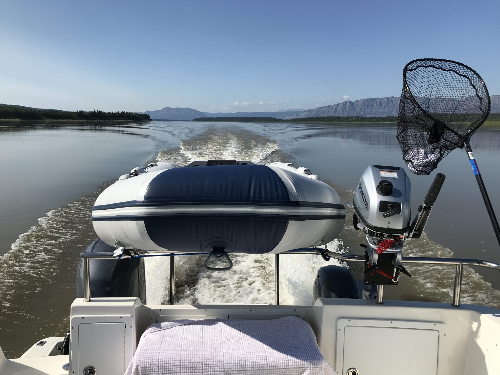
For five days now we’ve been making our way down Canada’s longest river, the 1,700-kilometre Mackenzie. We’ve now travelled over 950 kilometres, through mostly wilderness and we’ve faced some extreme navigation challenges. Somehow Larry Graf and I, aboard his 34-foot outboard-powered Aspen Power Cat, have managed to avoid grounding on the endless kilometres of rocks, shoals and sandbars that dominate this shallow, silty river. We’ve survived the blackflies, mosquitos and no-see-ums and haven’t had any trouble with bears or other wildlife. So far, the trip has been all about safely navigating our way downriver at 20-plus knots while being pushed by relentless currents of 3.5 to seven knots. Every moment while underway, we’ve had to fully concentrate on finding the next red or green can buoy or range marker. It’s been far more difficult than we had imagined.
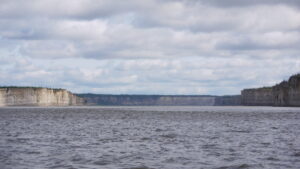 At the Ramparts the river narrows to 500 metres and runs for 11 kilometres through this striking vertical-walled canyon.
DAY 5: Earlier in the day, we’d transited the most feared section of the Mackenzie, the Sans Sault Rapids. Now we are approaching the Ramparts. Here the entire river, which is up to six kilometres wide in places, is funnelled down to just over 500 metres through a striking 11-kilometre-long vertical-walled canyon. Despite the narrowing, the current is running at only 3.5 knots. Fortunately, there’s plenty of depth and navigation is straightforward. We just have to stay in mid-channel. As we speed along, we marvel at the stark, 40-metre-high cliffs that the river has carved through the limestone plateau over millennia.
Just south of the Ramparts, the river widens to roughly three kilometres. The village of Fort Good Hope (population 500) is situated on the right-hand shore. Like most of the villages along the river, it has its origins in the fur trading days. Hoping for fuel, we attempt to beach below the village’s landmark church. We’re aided by locals shouting and pointing from shore, though we can’t hear them. The north wind has now increased to a steady 25 knots with higher gusts. The opposing current sweeps past the beach and after several attempts we decide it is too dangerous to land. Instead, we continue south through some of the largest seas we’ve seen to date. The Aspen handles the four to five-foot waves easily at 16 knots, thanks in part to its full-displacement knife-like hulls and high tunnel. Had we been aboard a planing monohull, we could have never made the same speed and the back-breaking ride might have stopped us.
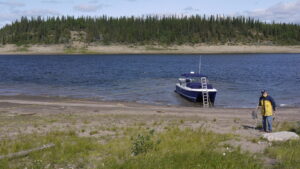
A few kilometres north we tuck out of the wind and seas into the mouth of Hare Indian River, just south of the village. Now out of the waves, we beach safely and take several lines ashore to hold us in place against an increasingly blustery crosswind. Fortunately, a friendly local woman comes to our aid and agrees to take us several kilometres to the fuel depot where, after waiting for the pump to be repaired, we fill our jerry cans under the curious eyes of local residents.
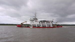 The river’s two Coast Guard buoy tenders are constantly on the move placing and repositioning buoys.
The wind has now increased to more than 30 knots and we watch ominous silt-filled williwaws blast up the main stem of the river like sandstorms. It is late afternoon, so we decide to lay over and wait for the wind to drop. We back off the beach and anchor mid-river. Throughout the afternoon and evening, locals in their pickups drive to the beach to look at the crazy tourists—something that has occurred at every village so far. We have only made 95 kilometres today, though some of it was hair-raising. We’ve now come over 1,000 kilometres and are about halfway to the Arctic Ocean.
DAY 6: We depart Fort Good Hope early. Our destination today is the community of Tsiigehtchic (pronounced see-da-chick), 354 kilometres away. Just after leaving, we are delighted to spot a prehistoric-looking muskox—with its curled horns and floor-length shaggy coat—browsing on shore. The muskox and a single small black bear are the only wildlife we’ve seen on the trip.
 Once safely beached at Fort Good Hope, we were lucky to find a helpful local woman to drive us to refill our 10 jerry cans.
Around a bend in the river, we spot the Coast Guard buoy tender Eckaloo beached parallel to the river. We’re invited aboard and meet with Captain Travis Rumpel in the wheelhouse. Captain Rumpel had given us valuable advice prior to leaving on this trip and it was enjoyable to meet him in person. He gives us some pointers on what to expect as we continue north and warns us that the actual marked channel has changed significantly from the charted channel and that buoys may be out of place or missing.
This next wide section of river has more drying flats and sandbars than we’ve experienced to date and the charted channel meanders from side to side. The Sailing Directions warn: “The shipping channel is subject to rapid changes due to erosion and silting, consequently the fixed and floating aids to navigation may be moved during the navigation season… For this reason, aids to navigation may not be as shown on the charts.” That certainly proves true!
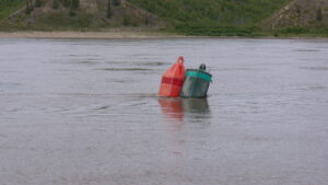 Dozens of buoys were out of place—or tangled together. Which way to go?
We set out into 25-knot headwinds and a steep chop. It isn’t long before we come across buoys that are aground or obviously out of place. Some red and green cans are even tangled together. We can no longer rely on any buoy to be in its proper position. Worse though, the river is kilometres wide and there are sections where the buoys are missing completely. We strain our eyes using the binoculars, but the river’s muddy brown water offers no clues to guide us through the jumble of sandbars and low-lying islands. Unable to rely on the charted depths, we are forced to weave our way out of shallows when we find ourselves in less than four feet of water. Left or right? We proceed cautiously, stopping and backing many times as we try another direction. Numerous times the topo map on our plotter shows us travelling over marked sandbars that no longer exist. At one point our props are only inches from the bottom. The shallow water alarm is constantly blaring, and Larry and I are tense and strung as tightly as violin strings. The plotter shows our tracked GPS course as a series of random circles, reverse tracks and squiggly lines, like a drunken sailor staggering down the road. Sometimes Larry’s guesses are right, sometimes mine are. It’s hard to maintain our cool knowing that running aground and then slewing sideways to the current in this wilderness could be the end of us.
 Crossing the Arctic Circle at latitude 66º 33′ north.
In the midst of all this, we cross the Arctic Circle at 66.5 degrees north and pause to take a selfie. We struggle for several seemingly endless hours before finally the buoys again start making sense. Had we been a few days later, the Eckaloo would have re-buoyed this section of river and our transit would have been much easier.
AFTER MORE THAN 320 kilometres, it’s a huge relief to arrive at the small village of Tsiigehtchic (population 175) at the confluence of the Arctic Red River. We tuck into the river mouth and anchor mid-channel. Nearby, the ferry that connects both sides of the Dempster Highway, which runs north to Tuktoyaktuk on the Arctic Ocean, bustles back and forth carrying people and cars across the river. In the winter, this becomes an ice road. We’ve now come 1,416 kilometres.
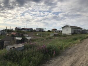 The tidy community of Tsiigehtchic (Arctic Red River).
In the morning, we watch a local fisherman pick a dozen fish from a short gillnet next to us. I drop a lure overboard, but don’t have any luck (we tried fishing half-heartedly in a couple of places, but never got a bite). We dinghy ashore and wander around the quiet community where we visit the requisite tall-steepled church (there’s two here) and pick up a few supplies at the small Northern Store outlet. These stores are pretty well the only commercial businesses in the small villages, and their origins reach back to the fur trade days. Like the other small First Nations villages where we’ve stopped, these are tough places to live. There are few jobs outside of working for the local First Nations band, and poverty, drugs, alcohol and suicide are said to be significant problems.
 DAY 7: Within an hour of leaving Tsiigehtchic, we reach another milestone: Separation Point. This is the point where the Mackenzie River fans out into the broad Mackenzie Delta—a 12,000 square-kilometre maze of channels and pothole lakes. The sun is shining and the seas are calm. However, because of the apparent wind and temperatures of about 16° C, we’re still forced to bundle up in our heavy gear, toques and gloves. We’re fortunate that the main channel is well buoyed, which makes for comparably easy navigation.
Watching the sounder, we’re surprised to see depths fluctuating from zero to 150 or more feet within a short distance. Not only do the bottom contours shift dramatically, but also the shoreline. It is being constantly eroded, evidenced by crumbling clay and sand banks and uprooted trees tipped into the river. Elsewhere the shoreline slopes gradually inland, often covered in lush green grasses. Throughout the trip, some of the higher riverbanks showed significant slumping where the permafrost had melted.
INUVIK (population 4,000) is the major business centre for the North. It is located off the main stem of the river, along what is known as East Channel. Unfortunately, the direct approach from the south has not yet been buoyed and it is too shallow to transit without those aids. Instead, the captain of the Eckaloo advised us to enter from the north end of the channel and backtrack 27 kilometres. The narrow, tree-lined East Channel is 100 to 150 feet wide and as long as we stay in mid-channel, we have at least 10 feet of depth.
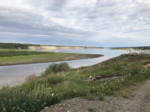 Looking down the Arctic Red River across the Mackenzie and the seasonal ferry that forms part of the Dempster Highway.
We pass barge facilities, oil storage tanks and then a boat launch with two small, modular-plastic floating docks. The boat launch is surprisingly busy at 20:00 with a dozen or so small runabouts coming and going on this bright sunny evening—and everyone is friendly and curious about what we are up to. We tie up at the dock, hoping its frail guy wires will hold us against sudden blasts of wind sweeping down the channel.
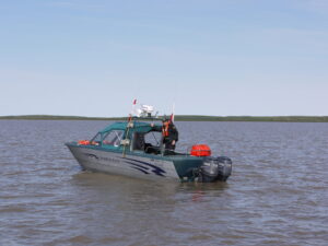 Entering the Arctic Ocean, we met up with this Fisheries enforcement crew monitoring the nearby Beluga whale harvest.
As usual, filling up our jerry cans is the first priority. Luckily, a gas station is only a few blocks away, so we immediately begin the familiar jerry-can-and-dolly dance. While getting fuel back in Fort Good Hope, we’d been given the name of Connor Campbell, a fellow who could help us out in Inuvik. We left him a phone message and then started filling our jerry cans. A fellow was fueling his pickup truck at the pumps and never-shy-Larry asked if he could drive us back to the boat. His name, it turned out, was Connor. What were the odds of randomly meeting up with our only contact in Inuvik? He was happy to help and after several trips to the gas station, we had the boat fuelled up.
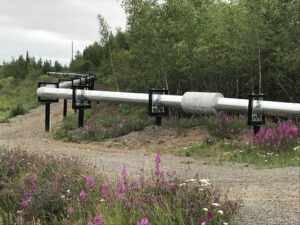 Heated (in winter) above-ground pipes for carrying sewage and water. The permafrost doesn’t allow for in-ground plumbing.
WE GO FOR a walk around town (Larry had booked a hotel room) and are surprised at all the above-ground pipes running all over the place. Turns out that because of the permafrost, all the city’s water and sewer lines flow through these heated pipes. Later we enjoyed our first restaurant meal since leaving Hay River.
We are now only 145 kilometres from the Arctic Ocean. Our plan is to shoot out to the ocean in the morning, then return to Inuvik the same day. I would then leave the boat and Larry would meet up with some family for the return trip upriver. However, we are facing a dilemma. The Coast Guard has not yet buoyed the shallow, winding channel to the Arctic Ocean. We’d already dealt with more than enough hair-raising navigation, and after looking at the charts, this final leg is looking too dangerous to attempt. We are despondent. We attempt to line up an experienced local to serve as our guide, but no luck. We then consider leaving the boat here, renting a car and driving to Tuktoyaktuk on the Arctic Ocean, or perhaps chartering a plane or helicopter to fly us there. At least we could say we made it to the Arctic Ocean. It would be a huge drawback to be stopped after coming more than 1,600 kilometres downriver and surviving all the challenges. Fate intervened though, when a local tour operator offered us a screen shot of his route to the ocean, overlaid on a Google Earth map. With this helpful aid in hand, we decide to go for it in the morning.
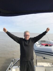 We made it! Celebrating our arrival in the Arctic Ocean.
DAY 8: We made it! After 1,700 kilometres we shut down the outboards and drift in the Arctic Ocean. We’re in a short tongue surrounded by an expanse of saltwater less than a metre or two in depth, so we don’t dare venture further offshore. For the final 15 or 25 kilometres, we’d passed north of the treeline and our surroundings were dominated by lush, flat tundra. A few patches of snow remained in the shadows. We strained to see polar bears, but they were elsewhere. A few kilometres before we reached the ocean, while trying to extricate ourselves from a four-foot shoal area, an aluminum skiff filled with jerry cans approached. We hadn’t seen another boat all day. It was a Fisheries and Oceans patrol boat, monitoring the nearby Beluga whale harvest. They noticed our fishing rods (we never did catch any fish) stowed in the dinghy and asked to see our fishing licences, which were in order. After a good chat, they moved on. Who would have thought?
What an amazing feeling to have made it to the end of our journey! We’d overcome all the many obstacles that could have seen us shipwrecked, stranded or dead. Luckily, we had no issues with the boat, the outboards, bears or other wildlife and the bugs were tolerable. Being here was as if an unbelievably heavy weight was lifted from our shoulders. My eyes teared up with joy and relief as I removed my shoes and dipped my toes into the ocean. After high fives and shouts of joy, I cracked open a celebratory beer and we soaked up the views out to the empty horizon.