
JUNE 1986: AS A YOUNG FAMILY WE HAD BEEN SAILING DREAMER, OUR O’DAY 25 , FOR FIVE YEARS, EXPLORING THE FABULOUS CRUISING GROUNDS OF THE GULF ISLANDS AND DESOLATION SOUND FROM OUR HOME PORT OF TSAWWASSEN.
We had crossed the Strait of Georgia in gales and calms, under sparkling blue skies and through driving rain, all to enjoy our favourite destinations. The 12-mile-wide crossing between home and the Gulf Islands was our weekend highway. During the long winter months my wife Carey and daughter Nicky would join me as we planned our next summer’s cruise: nautical charts, guidebooks and tide tables spread out on the dining room table.
I was ready for exploration further afield and believed we were skilled enough to challenge the West Coast of Vancouver Island. Barkley Sound, a 15-mile-long indent on the southwest corner of the island, was beckoning.
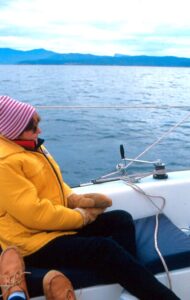
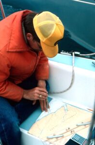 Bert calculating the distance to Port Renfrew visible at the far edge of the chart.
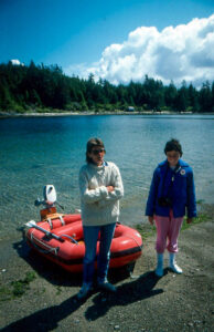
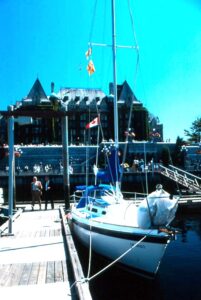 Dreamer, our 1982 O’Day 25 fixed keel moored in front of the Empress Hotel in Victoria.
It was a big step from cruising the protected waters of the Salish Sea to the open waters of the Pacific Ocean. To reach Barkley Sound would require sailing past Victoria and through Race Passage to Juan de Fuca Strait and the 80-mile trek to Cape Beale, the entrance to the sound.
Passage through Juan de Fuca Strait relies on tidal predictions, slack water being optimal. Currents at Race Passage can reach over six knots and, when running against prevailing westerly winds, can create a maelstrom on the water dangerous to craft far larger than our little 25-foot sailboat. Juan de Fuca Strait is 12 miles wide and stretches all the way to the Pacific Ocean. Our destination for the first day would be Port Renfrew 40 miles away, halfway to Barkley Sound. Port Renfrew offered no real facilities for small boats at that time, just a somewhat exposed anchorage. The remaining 40 miles to Cape Beale would be covered the following day.
What we couldn’t anticipate was the weather. I worried about the summer winds coming up Juan de Fuca Strait, right on the nose of any boat heading west. Those winds against ebbing current could hinder any attempt for a small boat to make headway.
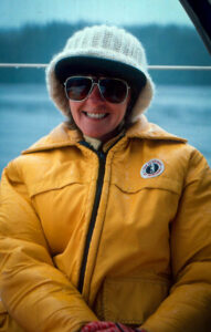 Carey settles in as the rain begins to fall. With no weather updates, we trusted that yesterday’s forecast had not changed.
LATE IN JUNE we sailed away from home on a carefully prepared Dreamer. The cruise through the Gulf Islands was comfortably familiar ending in a delightful visit to the docks of the stately Empress Hotel in downtown Victoria. Last minute supplies were loaded and we were ready for the long trek out the strait. Motoring out of the harbour with laundry still drying on the lifelines, we headed toward Race Passage with a degree of apprehension. The weather forecast called for showers and light southeasterly winds for the next few days, perfect for our intended passage. Thin grey clouds muted the sun, the flat seas meeting the hazy horizon.
Our timing at Race Passage was perfect. The current turned from a flood tide against to a large ebb with us, boosting our progress westward. It was a long day with the trusty Volvo humming beneath our feet, the ocean swells became apparent as we approached the open Pacific. Rounding the headland into Port Renfrew as evening descended, we anchored behind a small berm that jutted out from the shore near the head of the bay. It was early to bed in anticipation of a similar day tomorrow.
MORNING BROKE UNDER gloomy skies, the grey clouds near the treetops. We powered out of Port Renfrew as a light rain began spitting down. Without the appropriate channels on our old crystal VHF radio we had no weather update, trusting that yesterday’s forecast had not changed. Westbound along the shore of Vancouver Island we were now exposed to the increasing swells of the open Pacific Ocean to port.
We felt insignificant in the vast grey ocean as the clouds lowered further, enveloping us in a mist. We relied on paper charts, a compass and our eyeballs. A commercial LORAN set was far too expensive and GPS didn’t exist yet. With the reducing visibility I wanted to stay in visual range of the shore to starboard, logging headlands and lighthouses on the chart to assist in navigation along this “Graveyard of the Pacific.” We followed the fathom line on the flasher depth sounder as the mist thickened and almost hid the swells crashing on the nearby shore. This close to shore the swells were coming back from the cliffs. Waves hit us from both sides.
The hours dragged on as Dreamer faithfully drove on through the confused seas. The cold rain found its way into our rain gear, adding to our misery. But I was optimistic. We were still making good progress. The occasional lighthouse on the Vancouver Island shore drifted by in the mist, checked off on the wet charts strapped down in the cockpit. The light southeasterly breeze built into a wind, kicking up chop astern, adding to the confused seas and driving the steady rain under the dodger. We hoisted the jib to help us on our way, but Dreamer continued rocking jaggedly in the waves. Nicky was soon motion sick, the bucket in her lap. I was next, feeding the fish over the side. Carey was too frightened to be sick. I thought of turning back, but we were halfway to Cape Beale and the entrance to Barkley Sound. Turning back now would be against the 10 to 15-knot wind and chop blowing in over the stern. We plowed on.
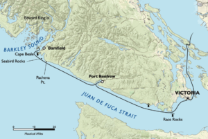
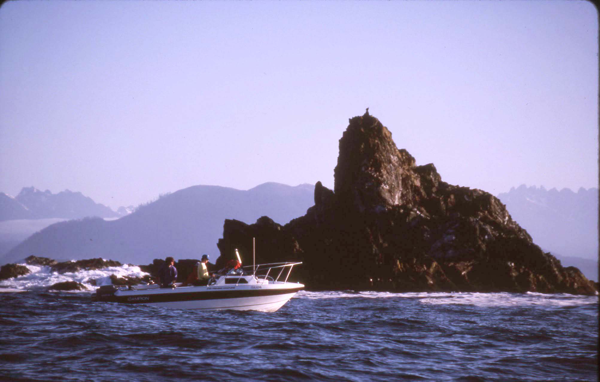
The last lighthouse before Cape Beale was Pachena Point, a headland leading into Pachena Bay, a five-mile-wide bay completely open to the swells of the Pacific Ocean. No place to seek refuge. Across the entrance to this bay was a series of islets and reefs known as Seabird Rocks. When I purchased the nautical charts for our trip there was a gap in the large-scale chart of Juan de Fuca Strait and the detailed chart of the Cape Beal headland. To cover this area I would have to purchase a larger chart that covered most of southern Vancouver Island. Detail was minimal. I had decided not to purchase this chart, reasoning that I would be able to see Cape Beal from Pachena Point without any problem. The guidebook had a hand-drawn diagram of the area. I deemed that to be sufficient.
By late afternoon we were abeam of Pachena Point. Visibility was about 200 yards in the mist and rain. Seeing Cape Beale in the distance was out of the question—Seabird Rocks were hidden in the mist. The only option I had was to follow the shore and fathom line all the way into and out of Pachena Bay. I was uncertain where Seabird Rocks were and wasn’t going to risk breaking contact with the shore without a definitive compass course that would clear the rocks. Going into the bay would add about two hours to our already long day. Both Nicky and I were still motion sick and hypothermia was becoming an issue for me. We were all exhausted by the constant, violent motion of the little boat in the confused seas. Although the heat was on below decks, I could not leave the tiller for even a moment in those conditions. I reluctantly adjusted course to follow the shore, cursing my stupidity for not purchasing that chart.
 Then Carey excitedly pointed toward something. She could see Cape Beale. I peered through the mist and could make out the grey hump of land and breaking surf where Cape Beale should be. I wanted to believe. I turned toward it, away from the shore I had been following for so long. Within a few minutes that wishful thinking came crashing down. The surf ahead was obviously the low-lying Seabird Rocks. I looked behind but the shore had been swallowed in the mist and rain. Going back was fraught with as much danger as continuing forward. Not a realistic option, and not where I wanted to go anyway! But how far did the reefs ahead stretch into open water? Could I get around them by motoring to seaward? Or to leeward? Would there be a gradual shallowing recognizable on the depth sounder or were there dangerous pinnacles jutting up from the sea floor? What should I use as a compass course as the crashing surf ahead disappeared through the thickening mist?
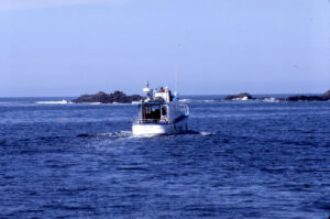
My numb fingers reached for the VHF microphone. I needed to contact the local Coast Guard station in Tofino in the hope they could identify me on radar or triangulate on my radio and provide a compass course to safety. Then, suddenly, the mist lifted. Within 10 minutes we were under broken clouds and sunshine. I could see Cape Beale a few miles beyond Seabird Rocks directly in front of us and all was well again. I altered course to give the rocks a wide berth and headed for Cape Beale and the safety of Barkley Sound, a grin across my face. And then the Volvo sputtered.
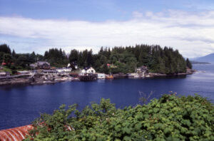 Views of Bamfield.
THERE WASN’T ENOUGH wind to fill the slatting jib, leaving us tossing around in cross swells and surface chop as we slowed. I had installed the engine myself to replace the noisy outboard on the transom, building a sound insulating box under the cockpit sole. I opened the cockpit locker and threw the fenders, deflated dinghy, spare ropes and sundry cruising equipment into the cabin, clearing the way to the engine box hatch. Spinning off the wing nuts that held the hatch shut I found sparks flying off the still sputtering engine. Sparks in an enclosed space on a gasoline engine—could it get any better?
I recognized the issue quickly and, after stopping the engine, dove down headfirst into the locker, feet in the air as the boat rocked in the waves. Fortunately, having been motion sick for the better part of the last five hours, I had nothing left to spill in the locker. I had to tighten the bolts holding the ignition coil to the engine block, the cause of the sparks and faltering power. The small engine started immediately and hummed back into power. The hatch was shut and we carried on, rounding Cape Beale and finally into the calmer waters of Barkley Sound.
 Carey and Nicky ashore on Edward King Island—solid ground!
The first available anchorage was aptly named Dodger Channel at Edward King Island in the Deer Group, just a few miles into the sound. We motored cautiously into the empty, unfamiliar anchorage and the hook was soon down and secure. Dreamer was finally stable. The motion sickness was soon forgotten as dry clothes were donned and sopping wet gear was thrown into the cockpit. Dishpan hands were warmed by the fire of the little Force 10 cabin heater. Litres of water were inhaled to counter dehydration—Nicky and I finally able to hold fluids. We had made it. We were in Barkley Sound. A light dinner was enjoyed in the warmth of the cabin, our faces raw from the hours of rain and wind. Although the clouds had not cleared completely, the rains had stopped. Exhaustion soon enveloped us and we succumbed to the sleep of the dead—Dreamer rocking gently in the low swell of the anchorage.
WE’VE BEEN BACK to Barkley Sound many times—modern technology has made the voyage much safer for small boats. And while it’s still a long way to travel, the rugged cruising grounds of the west coast of Vancouver Island are well worth the effort.